Wednesday 20 May 2009

Photo's taken on Walks at Burwardsley

Albert leads the way to the top

Ruth looks back to check John

B Party stop for an early drink.

C party stepping out in the country lanes

Saturday 9 May 2009

Our May Walk to Burwardsley

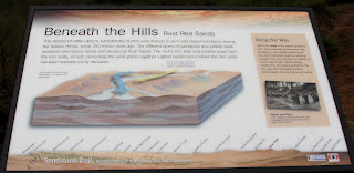
Our next walk will be to the Cheshire village of Burwardsley and the Sandstone Trail and will be on;
Saturday May 9th 2009
The coach will leave the car park at the back of Iceland at 8.00am

Burwardsley is actually mentioned in the Doomesday book as having a population of 9 and many of it's fields have Norman names dating from that time. It is thought that the people settled there because it was a natural clearing in the forest and there was plenty of water from wells and springs. During the 19th Centuray many of its cottagers were involved in glove making at home and there were no fewer than five shoemakers.


Click on any picture to view an enlarged version.

from Raw Head, pause to look back over the
beautiful sandstone countryside to Harthill.

Weather Forecast for area

Friday 1 May 2009

Three Walks from Burwardsley

A' Walk
Leader: Jenny Matthias
Distance:10 Miles

This is really a B+ walk but it is like an A walk in that there are no toilets en route! It is challenging in the length and number of stiles to be climbed, so many we lost count.

We leave the car park and head for the Eddisbury Way traveling along it for about two miles where we go under the railway and join Bishop Bennet way. This ends at a road we must walk along a short distance to find a foot path that will take us to The Sandstone Trail. Walking in the woods at the edge of Penkforton Estate we eventually climb Bulkeley Hill. If the weather is fine we may see Liverpool as well as the Cheshire Plain. We will leave the Sandstone Trail for a footpath which will bring us to Sarra Lane then back to the Candle Workshops along a road once more.

B Walk
Leader: Keith Scott
Distance:8.5 miles
Total Ascent/descent: 1570 ft

Cheshires sandstone edge strikes down the heart of the county like a clenched fist. Great knuckles of rock and steep, wooded slopes rise steeply from the lush pastures of the Cheshire Plain. Here you follow a glorious section of the Sandstone trail, passing the ramparts of Iron Age Maidon Castle. This hillfort crowns Larkton Hill. Raw Head is the highest point and gives vast views that take in part of Wales and seven English counties.

Starting from the Candle Workshop car park, the walk includes wooded slopes and rocky outcrops giving excellent views across the Cheshire Plain. This walk is a gentle undulating walk as it meanders through tiny villages and along the most spectacular stretch of the Sandstone Trail and although the highest point at Raw Head (see picture below) is only 746 ft, giving vast views of parts of Wales and seven English counties on a fine day, the ups and downs will give us that 'B Walk' type of ascent and prepare us to enjoy the refreshments at the end.

Some sections of the walk are on public roads,but only for short distances. There are not many sections where mud s a problem.

B Walk route (anti clockwise)


Admiring the views over the Cheshire plains


John views the memorial plaques on the trail


John at Raw Head, the highest point on the undulating walk.


C Walk
Leader: Rod Sellers
Distance: 6 Miles
Ascent: 300Ft

This walk takes us over farmland to Peckforton Gap, thence onto the wooded slopes of Bulkeley Hill. Here are dramatic views of the flatland at the foot of the escarpment. The path drops, leaves the woods and crosses fields until it climbs again to Raw Head, where we lunch at the highest point of the trail.
We return downhill, through a pine plantation, over fields and back along the road to Burwardsley and afternoon refreshments.