Our next walking will be on
Saturday 11th July 2015
and will be from
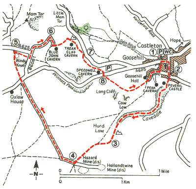
Castleton
a honeypot village in the High Peak district of Derbyshire

Castleton
is an outstandingly pretty village situated at the head of the lovely
Vale of Hope, in the heart of the Derbyshire Peak District National
Park.
Castleton is surrounded on 3 sides by steep hills and the mighty bulk of
Mam Tor looms high, 2 miles to the north west of the village. On a
hill, overlooking Castleton, is the ancient Peveril Castle.
...........click to follow
There will be 3 walks;
- A Walk led by; Peter Hitchcock
- B Walk led by; Beverley Kelly
- C Walk led by; Doreen Lethbridge