Friday 14 November 2008

New Year Walk and Festive Meal at Chipping


Our next walk will be our New Year walk and festive meal at the 'Dog and Partridge near Chipping on Saturday January 10th.

There will be two walks;

led by George Mann

Just Less than 5 Miles.
Total ascent: 610ft

Our walk today is mainly over farm roads and tracks as the underfoot conditions in the fields have been impossible with mud over the boot-tops.

We leave the car park passing through the town joining the road to Legram Mill and turn off this to a farm road leading to Chipping Lawn Farm. We continue on to Park Gate then over fields to join a bridle path leading along to High Barn. This takes us on to the road leading to Burnslack which we follow down to another farm track to Windy Hill Farm, Birchen Lee Farm then back to Chipping Lawn Farm and retrace our route to the town car park with a healthy appetite for a sumptuous festive meal at the Dog and Partridge.


C Walk led by Marion Young

to follow the same route as in previous years

If you have not already booked, contact Shirley ASAP.

Welcome to Chipping


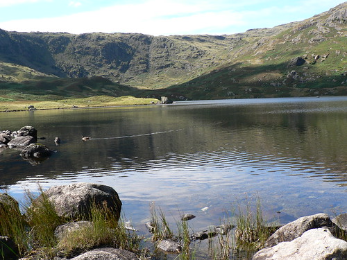
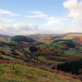
Chipping is situated in the Ribble Valley on the edge of The Trough Of Bowland.

Laund lambs going to the annual sheep sale


A well kept secret to many, This picturesque Lancashire village has won a number of best kept village competitions over the years. The village is known to be at least 1,000 years old and is named in the Domesday book as 'Chippenden' the name coming from the medieval 'Chepyn' meaning market place. Chipping really thrived during the Industrial Revolution when there were seven mills located along Chipping Brook. Today only one survives the famous chairmaking factory of H.J.Berry where furniture has been designed and made since the 1890’s.

The Trough Of Bowland is both a delight and a pleasure with its rolling pastures, working farmland and dense forestry. The area is classed as “an area of outstanding natural beauty” and it certainly lives up to expectation. The Forest of Bowland occupies most of the north east of Lancashire. It consists of barren gritstone fells, deep valleys and peat moorland. It's an attractive alternative to the overcrowded Lake District, and today this grouse moorland is also used for walking and cycling. The name 'forest' is used in its traditional sense of 'a royal hunting ground', and much of the land still belongs to the Crown. In the past wild boar, deer, wolves, wild cats and game roamed the forest. The origins of the name Bowland most likely came from the long-standing connection of the region with archery - the 'land of the bow'.

The twin peaks of Parlick and Fairsnape viewed from Beacon FellJust to the North of the village the access areas of Clougha, Fair Snape, Wolf Fell and Saddle Fell have been opened up to the public by access agreements negotiated between Lancashire County Council and the owners. This means that over 3,260 acres of open country is now open to walkers.

For more details about Chipping, click here

Monday 10 November 2008

What a Surprise!

Non of us expected good walking weather when we set off with rain on the windscreen and dull clouds, but a surprise was awaiting us. Granted it was still drizzling when we started our walks, both along the canal path, but before long it dried up and the sun kept on appearing, giving us good views and pleasant walking conditions except for one patch where the C party had to wade through mud.

A really pleasant day was had by all with some excellent refreshment stops back in Llangollen and an earlier start home at 4pm as everyone was ready by then.

Photographs of the walks will be posted soon.

Our next walk will be our New Year walk and festive meal at the 'Dog andPartridge in near Chipping on Saturday January 10th. If you have not already booked, contact Shirley ASAP as spaces are nearly gone.

B Party Photographs

C Party Slide Show


Click on picture to view controls and stop the show.

Tuesday 14 October 2008

November Walk from Llangollen


Our next walk will be from the famous Welsh town of Llangollen nestling within the beautiful Dee Valley in the North East of Wales. It is a town of varied parts, with plenty to interest the most discerning of visitors. You will probably know it for the Eistedford, or the horse drawn canal boats, or the Steam Railway, but there is plenty more about it so take a peek here

There will be two walks;
  • B Walk, led by Bill Farr
Distance: 8.5 miles
Total Ascent: 1,000ft

  • C Walk, led by Norman Jones
Distance:6.5 miles
Height Gain: 875ft


The coach will leave the back of Iceland at 8.00am on Saturday 9th November 2008. Pre-booking is essential through the Church office, but there are often spaces available for visitors (or for those unable to walk but wishing to visit with us).

B Walk Llangollen November 2008

Walk Leader: Bill Farr
Distance: 8.5 miles approx
Total Ascent: 1000 ft
Click on map to enlarge.

Starting from Llangollen, for the first 4 miles the walk is mainly on the flat, initially alongside the canal then on quet roads and farm tracks in the Dee Valley.
After that, crossing the A5 to climb gently through woods to the village of Vivod (c500ft), then along undulating quiet roads and farm tracks back into Llangollen.

Good Paths or quiet roads throughout and hopefully, good views of the Llantysilio Mountains and the Dee Valley.

C Walk Llangollen November 2008

Walk Leader: Norman Jones
Distance: approx 6.5 miles
Height Gain: 875 ft ( including going up to Castell Dinas Bran)

We head north out of Llangollen over the River Dee bridge and up to the quayside of the Llangollen branch of the Shropshire Union Canal. This is where the horse drawn and other boat trips are operated. After 1.5 miles along the pleasantly wooded towpath, passing the Royal International Pavilion on the left, we cross the canal and main road to join a footpath. This goes past the ruins of the Valle Crucis Abbey and continues through fields and woodland, with a view beyond the Eglwyseg River Valley to the traffic of the Horseshoe Pass about 1.5 miles away.

A short section along a lane, then through fields to join the Offa's Dyke Path with the prominant cliffs of Eglwseg on our left. After about a mile we leave the path and reach the base of the hill topped by Castell Dinas Bran ruins. The top is a superb viewpoint in reasonable weather and we can decide whether to go to the top, or around the base, when we get there.

After the hill, it's gently downhill for about a mile into Llangollen.

Monday 13 October 2008

A Sunny Day at Grassmere

After a very wet period we set off on the coach with a lot of scepticism about an overnight change in the weather forecast, not helped by rain on the windscreen, but by the time we got to Grassmere the sun was out and blue skies had appeared. It was a lovely autumnal day, warm, dry and little wind, showing off the colours superbly but some found the water on the ground a bit of a problem. The B party reached Easdale tarn to find the stepping stones had disappeared and so had to change their plans and return by the route they had taken up. Once back in Grasmere they completed the circuit of the water to make a total of 8 miles.

Click on individual pictures to enlarge


The B Party on the way up to Easdale Tarn.


Where are the Stepping Stones? They were there on the 'reckie'.


Lovely Autumnal Colours.


The C Party near the Rydal Caves.

More photographs from Bev's walk
If the slideshow is too quick, click on pause and then advance by clicking the arrow.


Monday 6 October 2008

Monday 29 September 2008

Grasmere Walk Details


click on photos to enlarge
Possible A Party Walk?
There may be an A Party Walk, but this has not been decided yet. Ask on the bus.


B Party Walk
Leaders: Shirley and Joan
Distance: approx 7.5 miles
Height gain: 1276 ft

When the Wordsworths lived in Grasmere in the early 19th century they called Easedale 'The black quarter' for that is where the bad weather comes from before it hits the village,and we
can vouch for the bad weather it rained all day and it was very wet above ,middle and feet wise the day we did the reckie.

Hopefully we will have a better day as we gradually ascend via Allan Bank and Goody Bridge up Far Easedale to the tarn.We will enjoy our lunch at the Tarn and weather permitting circumnavigate the tarn where there are some wonderful views.

Our homeward journey is via Sourmilk Gill and back to base for a well earned cuppa.
The walk is about 7.5 miles from the coach park and back.
Shirley and Joan


C Party Walk
Leader: Heather Sissons
Distance:
5.5/6 miles
Height gain:676ft

A lovely scenic walk following the classic low level walk around Grasmere and Rydal Water.

Going out of the village we pass Dove Cottage and then a moderate climb to take the walk along the Coffin Trail to Rydal Mount, with some wonderful views across both waters and along the valley.

ON the return route we shall visit the Rydal cave as we walk along side the south flank of Rydal Water and Grasmere. The final bit is along the road back into Grasmere and the Garden Centre and various other refreshment venues.

The route is undulating but hopefully with great views.

Grasmere is lovely and peaceful, even in the rain.

Thursday 18 September 2008

October Walk at Grasmere


Our next walk will be on Saturday 11th October to the ever popular area of Grasmere, famous for Gingerbread and William Wordsworth. It has been a regular venue for the club because of its wonderful views, variety of walks and variety of shops and refreshment venues.

Grasmere is a charming village right in the heart of the Lake District National Park in Cumbria, England and was once the home of the famous poet William Wordsworth; today you can visit two of his former homes - Dove Cottage and Rydal Mount. Also in the centre of Grasmere is St. Oswalds Church, the churchyard of which contains the Wordsworth family graves.

The coach will leave the back of Iceland at 8.00am on Saturday 11th October 2008. Pre-booking is essential through the Church office, but there are often spaces available for visitors (or for those unable to walk but wishing to visit with us).
There will probably be 3 parties;

  • A ?
  • B led by Joan & Shirley
  • C led by Heather
More details will be available nearer the date, but should be 'on site' by 4th October.

We last visited Grasmere on 11th November 2006 when we had a drizzly misty day as shown by the photograph below.

Photographs from The Trefriw Walks

We had a lovely day for our walks in Trefriw with the first bit of sunshine for some time. Everyone seemed to enjoy themselves and enjoyed the lovely scenery. Here are some photographs taken on the walks. (Click on the pictures to enlarge)
Our next walk will be to Grasmere on Saturday October 11th and preliminary details will be on the website this week, with walk details added by October 4th at the latest
C Party stocking up for the walk

The Fairy Falls in the morning.

C Party Lunch Stop

These had more comfortable seats!

The Monument


The Fairy Falls again.

Trefriw

B Party arrives back in Trefriw
(aiming for the pub?)
This group looks a lot happier!

And here comes the tail.

Time to get those boots off!

Thursday 28 August 2008

Our Walk Routes at Trefriw

Click on map (or any picture) to enlarge it.

Weather forecast for Trefriw

Fairy Falls, just above Trefriw, both parties will be visiting here.


Lake Geirionydd

B Walk
Leader: Gwyn Jones
Distance: approx 8.5 miles

The walk explores the landscapes around the lakes Crafnant and Geirionydd. From Trefriw we climb up through the woods to the monument at the northern end of Geirionydd (ascent to this point is approx. 650ft). From here we head N West towards lake Crafnant and walk round its north western shore. Then we climb up through the woods (ascent approx. 280ft) then down to lake Geirionydd. We walk along its eastern shore before we head down back to Trefriw. Most of the walk is on good trails and tarmac roads.

C Walk
Leader:Terry
Distance: approx 6.5 miles

From the car park in the centre of the village, cross the main road in front of the Woollen Mill and turn right. At the end of the row of shops - opposite the Fairy Falls Hotel - turn left and walk up the hill. After a few yards, turn left onto the waymarked Trail 4 that will take you to the Falls. From the Falls climb up to the footbridge and follow the Trail 5 waymark signs.

The Trail takes you up into woods above the village and climbs steadily up 680 feet before Trail 8 branches off up a steep slope to a cluster of houses at Penrallt. This lies in a natural hollow and after the last ice age was probably a shallow lake. Over time this has dried out and silted up to leave a large area of marsh and bog which has been colonized by willow to form a Willow Carr.

From here, the Trail winds around the small community of Llanrhychwyn, including taking in the famous 6th Century church.

During the 19th century Llanrychwyn had a larger population than Trefriw with 87 recorded houses and a population of 376. By 1851 the population had increased to 586, due mainly to the flourishing mining industry.

From Llanrhychwyn Church, Trail 8 takes you into Gwydir Forest before a short stretch of narrow road and then a path which descends through woodland to the Conwy Valley floor. The trail crosses the B5106 (Trefriw to Llanrwst) road). WARNING: This road can be dangerous and you are advised to cross with caution. Trail 8 takes you along a farm track, a narrow footpath, and then onto the Cob (flood defences) and along the River Conwy to the suspension bridge. To return to Trefriw follow Trail 1 or extend your walk by following Trail 2 in a loop back to the village.

Before we commence the walk we can have coffee or tea plus a scone at the local provisions shop on the right of the of the Woolen Mill. A coffee shop can also be found here [ not so sure of hot scones though]?.


Thursday 14 August 2008

September Walks from Trefriw

Our next walk will be from the ever popular Trefriw in the beautiful Conwy Valley. We will park by the Old Mill where refreshments can be obtained and any last minute shopping from the Mill Shop (serious shoppers after the walk please!) The views here are spectacular, with high peaks and plenty of water - hopefully already there.

We last visited Trefriw in May 2004, when despite a rather damp start to the day we had a great walk.

The coach will leave the back of Iceland at 8.00am on Saturday 13th September 2008. Pre-booking is essential through the Church office, but there are often spaces available in August for visitors (or for those unable to walk but wishing to visit with us).
There will be 3 parties;
  • A ?
  • B led by Gwyn Jones
  • C led by Terry
More details will be available nearer the date, but should be 'on site' by 6th September.

Fairy Glen waterfalls in Trefriew

Surveying the falls from the bridge.

2 views on Llyn Crafnant ( I think, not mine!)

Sunday 10 August 2008

Haworth......Saturday......August. 9th. 20008

Steam loco 41241 arrives at Oakworth Station on the Keighley and Worth line.


What a day!!, if we had all been DUCKS we would have been in our 'element' !!

It's the first time I can remember being 'rained upon' all day without a break, we all returned to the coach absolutely soaked to the skin, literally.
But hey, we were in the beautiful Emily Bronte countryside, magnificent scenery, swathes of lovely heather, ( and not a Gypsy in sight !) green fields, small streams, waterfalls, stone bridges, styles, kissing gates, ( no-one was seen taking advantage of these.) we had it all on this great walk. (Except sunshine), but
the thing that kept us all going, and able to ignore the inclement weather was, great company and interesting conversation.
The 'A' and the 'B' walkers were fortunate in finding a derelict building which had a good solid roof, enabling us to enjoy our lunch in dry conditions. Unfortunately the 'C' walkers were not as lucky, but they did enjoy a warm start in there usual cafe venue.
The 'A' walkers had to change tack on a number of occasions due to the low lying mist, but each diversion brought more enjoyment.
All adding up to us all wanting more, and looking forward to the September jaunt with enthusiasm.
Thanks again to our leaders: Jenny, John, and Norman.

C Party arriving back in Haworth.

B Group Walk

The weather forecast was atrocious – wet, wet, wet and windy. As the coach set off in dry conditions optimism prevailed, soon to be dampened as the coach encountered the rain (by then, in Yorkshire). So, the mood changed to one of resignation and how to remain dry for the longest time – ‘do the C walk’ is the answer. The net result of these calculations was the B walk registered a meagre 8, actually 6 and 2 guests against an average of 12 plus – such a pity as the walk to Top Withins (on a good day) is stunning with wonderful views. The B walkers got off to an early start through the village onto Cemetery Road and then the Moors. Rain lashing down! An hour’s walking brought us to the Bronte Seat and the bridge over the beck, where we met the Group A resting after overtaking us just before the Bronte Seat. There was some talk of defection as the B walk is shorter, but as the A’s got going up the sharp slope and the long incline to Top Withins, the B’s followed a respectful distance behind. After some 2 hours of leaning into the wind and rain we reached the dry sanctuary of Top Withins looking forward to sitting down for a rest and lunch……only to find the shelter full up with A walkers. They soon left and we had the place to ourselves. But there’s little point in having a long break when you’re soaking wet and there’s more to come so, off we set for the return journey to Howarth. It was a relief to have the wind and rain behind and to know that it was almost all downhill. Still rain lashing down!! On, to Stanbury past the alluring attraction of a number of warm and welcoming pubs to a right turn and down across the lake road. A last uphill section to regain Cemetery Road and our path into Howarth. Rain still lashing down!! Then a split in the party, 4 for a cuppa and 4 for a pint before returning to the coach and ….at last a dry change of clothes.

A good walk of 7 and ½ miles spoilt by wind and rain with a walking time total of just over 3 hours 45 minutes.

John Smith


More photo's of the walk

B Party ready for the off!

B Party find somewhere to have lunch

2 of the A Party wet but happy


Haworth streets pretty deserted


What a difference to our last visit