Friday 24 July 2009

August Walk from Bakewell

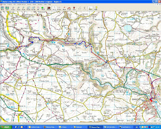
Our Walk this month will be from Bakewell in Derbyshire and the Peak District on


Saturday 8th August

The coach will leave the car park at the back of Iceland at 8.00am. Visitors are welcome to join us by contacting a member or Holy Trinity Church Office (878913).

We last visited Bakewell in November 2007 and many of us have happy memories of 3 very enjoyable and varied walks.

There will be three walks;
  1. A Walk led by Beverley Kelly
  2. B Walk led by Les Gibson
  3. C walk led by Marion Young
details of each walk are below (click on the relevant walk)

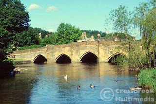
Bakewell in Derbyshire and the Peak District , is a beautiful, small, market town situated on the River Wye which is crossed by a 13th century 5 arched bridge still open to traffic. The bridge had been widened in the 19th century.

Bakewell was mentioned in the Domesday book as having a church and 2 priests signifying its importance even then. In 1502 Bakewell was owned by the Vernon family and passed on to the Manners family in 1567 when Dorothy Vernon married John Manners. Their son, Sir George Manners married Grace Pierrepont who in 1637 founded the grammer school, Lady Manners School. Monuments to the Vernon family can be found in the All Saints Parish Church which stands in a commanding position on the hillside where the town started.

The Rutland Arms Hotel in the centre of Bakewell replaced the White Horse Inn, which together with some other buildings was demolished in 1805 to form Rutland Square. It was built to cater for coach travellers and in 1818 as many as 600 travellers passed through the town. The Hotel has a literary connection in that Jane Austin is reputed to have stayed at the hotel whilst writing Pride and Predudice. Bakewell has been identified as Lambton.

The famous Bakewell pudding was also invented accidentally at the Hotel, when a cook misinterpreted instructions and poured egg mixture over the jam instead of mixing it in the pastry and what should have been a tart was now a pudding. Bakewell puddings can be bought at several shops in the town centre.

For more information about Bakewell, click here;

and Here;

Weather forecast for Bakewell, click here;
A Walk (Bakewell) A Sensual Walk through the Wye Valley


Walk Leader: Beverley Kelly

Distance: 10 miles

Total ascent: 1700ft, Descent: 2350ft

This is truly a walk to delight the senses as we wander through an unspoilt valley which once thundered with steam trains on the St Pancreas to Manchester line, but is now peacefully returned to a ‘Garden of Eden’, full of the heady scent of wild flowers as the river sparkles in the sunshine and roars over the waterfalls, providing a wonderful habitat for trout and creatures great and small,

not forgetting the ice cream and cakes!!!


We start our walk going downhill towards the Blackwell Mill Junction and the start of the Monsal Trail


Chee Dale is a real delight as the river passes through steep limestone cliffs and the pathway here is on these 50-60 stepping stones


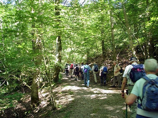
and we pass masses of wild flowers, heady with scent to attract the insects of all sorts.


The River Wye rushes under this viaduct which is also used for absailing (under license, so wewill not be doing it), but we temporaly leace the river and ascend to join the track again to Millars Dale.


First we pass these limestone kilns cut out of solid rock, which we can inspect. The concrete front is a later addition.


Millers Dale Station, now used by park rangers. You can imagine trains in this busy 5 platform station passing over the nearby iron viaducts, but today there are picnic benches and an ice cream van round the corner!


We are in Water-cum-Jolly Dale and meet our second group of rock climbers. We choose the easier way out, but beware the pathway is liable to flooding and there is plenty of mud. We can clean our boots further on.


This is Cressbrook mill, the second mill which was philanphropic to its child labour, even providing a terrace of dwellings for them, unlike Litton Mill at Millars Dale which worked its children to death. Both are now luxury dwellings.


The lake at the end of 'Water-cum-Jolly' dale, full of trout and an ideal spot for lunch. Cressbrook Hall can be seen above the trees.


Too soon and we have reached Monsal Head with the viaduct below and one of the most wonderful views of the area. Maybe afternoon tea here (depends upon you), then it is through Longstone village and downhill as we coast towards Bakewell Station and the coach. A long but beautiful journey if the weather is right.


Plenty of time to enjoy all the delights as long as we keep moving at a respectable pace


B Walk through 3 delightful villages and alongside tumbling rivers

Walk Leader: Les Gibson
Distance: approx 9 Miles
Total Ascent/descent: 1400ft


Lots of enjoyable variety on this lovely 9 mile walk, stunning views, exciting river rapids, with rainbow trout to be seen. Four delightful villages, stretches of open countryside, and a few short stretches of road. There are approx. 7 stiles, 7 gates, and 9 'slits' in stone walls to negotiate. There is some climbing to do, but nothing too serious .There are lots of fantastic gardens to admire on route. Lunch will be taken in or close to Alport, and if it's raining lunch will be in the church porch, that will be 'close knit and cosy!


When in Over Haddon, watch out for the 'dead lion'!!, and the observant ones will see 'Tweedle-Dee and Tweedle-Dum plus a stone Bulls head in Yulegrave. There is also an interesting 'memorial' sun dial on the church wall in Over Haddon.


All in all, it was a great walk to recce, and if we are blessed with dry weather, it will be even greater.


C Walk (Bakewell)

Leader: Marion Young
Distance:5.5 miles
Total Ascent:


A steepish climb up the high wood flanked ridge to the East of Bakewell followed by a stroll down through pasture and woodland concluding through the meadows of the meandering clear watered river Wye back to the Bakewell Showground.

A 5.5 mile, 9 km, round trip leaving plenty of time to grab a Bakewell Tart and explore the many shops and cafes in the town.


Monday 13 July 2009

B Walk (Elterwater) Photographs


Out of Elterwater and soon on a steady climb upwards with the sun shining and promising a lovely day.
The Three Shires Inn and it was hard to not stop for refreshment.

Lunch stop at Blea Tarn


Some of the group who had a sudden burst of energy, were found at the Wainwright Pub.

Posted by Picasa

Photographs of C Party Walk at Elterwater


Posted by Picasa

Friday 3 July 2009

July Walk from Elterwater

Our walk this month will be from the heart of the Lakes and is a favourite area for all keen walkers and climbers. The village is only small, but is probably most famous for the Britannia in which dominates the village green and always has customers at the outside tables enjoying the clear lakeland air and views. It is also where the Judy Boyes, an ex Formby artist, has her gallery.
More details and history of Elterwater can be viewed here

The coach will leave the car park at the back of Iceland at 8.00am on
Saturday 11th July 2009

There will be 3 walks;
- approx 10 miles, total ascent 1970 ft
- approx 9 miles, total ascent 1400ft
- approx 6 miles

Weather Forecast for Kendal click to view
(nearest weather station)

A Walk (Elterwater)


Leader: Jennifer Matthias
Distance: 10 miles
Total Ascent/Descent: 1970ft


This is a good 'A Walk' in the Lake District. We leave the car park and walk up the road to cross the B5343 continuing upwards to Red Bank. We will follow the ridge as it undulates, up and down reaching about 1600 feet, for over three miles. There are great views, Windermere, Elterwater, Rydal Water, Grasmere, the Eskdale Valley and the hills Fairfield, all the Langdale Fells and some beyond.
Dropping down to Stickle Tarn in the shadow of Harrison Stickle and Pavey Ark before our steep descent to the valley floor along Stickle Ghyll. Our return to Elterwater starts along a farm track then a footpath following the river to the car park. At times the path is narrow and rocky and we will have to maintain a good pace to get back in time.

B Walk (Elterwater)

Click on map to enlarge

Leader: Beverley Kelly

Distance: 9 Miles

Total ascent/descent: 1450ft


This is a delightful B walk with plenty of variety as it wends its way through the two Langdale valleys, but it is not a stroll. If you are a B walker then you will manage it with ease as you cope with the climbs and different terrains, enjoying the feast of views before you and will finish the walk tired but satisfied


1. The first climb done and time to admire the views


2. Down Dale End and the mighty Wetherlam comes into view,

then continue down


3. Past Wilson Place to join the Little Langdale Road


4. And to walk past the Three Shires Inn—sorry no time to go in!


5. Continue downhill to cross Slaters Bridge

6. And along the valley with Lingmoor Fell to the right.

A difficult section ahead of us.

7. Blea Tarn may be our lunch stop,

but I suspect we will be hungry before here!

Highest point ahead at 780ft


8. Steep Descent towards Great Langdale,

the Langdale Pikes and the Old Dungeon Ghyll


9. Relative easy walk back along the Cumbria way

with the A Party ridge alongside us

Back in Elterwater Village