Wednesday 8 November 2023

Walk B, CONWY , 11th November

Walk lead by Pat Guy, 7.5 miles, 1,300ft of climbing.


We will start this month's walk by walking down to the quay just to visit the toilets (free). Then we shall walk through the town to pick up the path at the foot of Conwy Mountain and follow this lower path all the way along to the Sychnant Pass. After crossing the road we follow a path passing a small lake on the way to Llechwedd and on to Groesffordd. We will then cut across a holiday park and fields and head into Conwy passing a mast and some woods. After all the recent rain the paths are wet and muddy in parts.


Tuesday 7 November 2023

Walk A, CONWY , 11th November

Walk lead by Brian Thorne, 11 miles, 1800ft of climbing.


This is a fine, circular walk which requires a brisk pace to be kept throughout.

Leaving the coach, we begin with a sharp initial climb, up through the woods south of Conwy. Field paths and a little road walking lead us up to and around the Iolyn Park caravan site and on to the village of Henryd.

Climbing up through the woods of Parc Mawr on a steadily increasing gradient, we are rewarded for our efforts with stunning views of the Conwy valley and surrounding mountains, before joining the Pilgrim's Way and reaching our lunch stop at Llangelynnin old church.

A steady walk along high ground on the North Wales Path leads us to the top of Sychnant Pass and then on to the now almost obligatory, "Sting in the tail," our final climb, up Conwy Mountain and then down, to well-earned refreshment.


Monday 6 November 2023

Walk C, CONWY , 11th November

Walk lead by Gwyn Jones, 5.5 miles

I had planned to take the ‘C’s’ up onto the slopes of Conway mountain to obtain the views across to Anglesey but on the recce there was so much mud and water that I am now keeping, as much as possible, to firmer ground (although there are still some muddy patches on the walk). We start along the riverside as far as we can and then divert onto Mountain Road.  Here we make a steady climb before dropping down to cross the Sychnant Pass road and head up to the old Golf Club House. From here we enter a field  and take  a path up to join a lane which takes us downward to Conwy. There are a number of upward slopes but nothing strenuous and there are no stiles. 


Thursday 12 October 2023

Walk C, GRASMERE , 14th October

Walk lead by Mark Stanford, 6.36 miles, ascent 500ft.

The Coffin Trail, Rydal Hall, St Mary's Church, Rydal Water, Grasmere & St Edmunds Church.

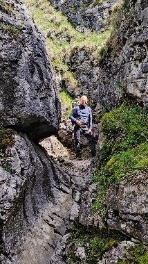
6.36 miles. 500ft of ascent. Terrain: mostly well-made paths and mettled roads, there's one section of rocky path (approx. 200 yards) on the Coffin Trail where we will take care and time.


 A C party favourite, we'll enjoy a coffee in Grasmere before heading off at 11am. Care will be needed as we cross the

A591 before heading up to the ancient Coffin Trail, once we've gained the height, we follow the contours to Rydall.


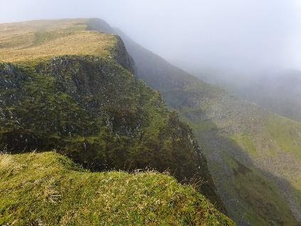
The path offers spectacular views of Grasmere and Rydall Water with Silver How and Loughrigg forming the backdrop. We'll enjoy walking through the formal garden of Rydal Hall before finding respite under the Yew tree at St Mary's where we stop for lunch, making sure to leave time to explore the Church.

We'll hopefully set of around 1.30pm recrossing the A591 with care again. We cross the River Rothay before heading to the shoreline of Rydall Water and then crossing the shoulder of Loughrigg with great views across the lake towards Nab Scar and the Fellfield Range. The route now heads down through woods to a higher stretch of the Rothay flowing from Grasmere. Crossing the bridge, the path takes us towards a second crossing to the bank just below the weir marking the lake's circumference.

The final section follows the wooded shoreline before heading up to the lane for the final mile into Grasmere, we'll stop to look at St Edmund's Church and Wordsworth's grave. We should be back for 3.30pm leaving time to queue for gingerbread and find refreshments. Grasmere, in my opinion, is rather better served by tea shops than decent purveyors of fine ale, although Gwyn tells he knows a place!


Friday 6 October 2023

Walk B, GRASMERE , 14th October

Walk lead by Pat Guy, approx 8.5 miles, ascent 1400ft.


The objective of this month's walk is a circuit around the bottom of Loughrigg Fell passing Loughrigg Tarn. We start by walking through Grasmere village and taking the road near to Grasmere Lake for about 1 mile before taking a path through Red Bank Wood, shortly after this we walk through an Arboretum for a short while before taking another path to Loughrigg Tarn (one of the many gems of the Lake District). We then follow an undulating path around the bottom of Loughrigg Fell to a quiet road for just over a mile to cross the River Rothay and the A591 then a short climb to Rydal Hall. We then take the Coffin Route all the way back to Grasmere passing Dove Cottage on the way. The walk is about 8.5 miles long with about 1,400ft of ascent.


Walk A, GRASMERE , 14th October

Walk lead by Peter Hitchcock, approx 9.2 miles, ascent 2500m.

This serious but scenic route will be a narrow horseshoe from Grasmere up to Fairfield and return via Stone Arthur.  Cloud permitting, the views will be classic, however, the 9.2 mile trek with gradual then steeper ascent to 2500m above the town will be challenging but worthy of an ‘A’ grade walk!

For a slightly easier climb ratio rate, we shall walk the route clockwise setting out from Grasmere (with its 50p toilet charge at the car park) through parts of the town you may not have seen before to take the Patterdale/Coast-to-coast path, (after about 800m walk along the road), up a glorious glacial valley to House Gap, just abeam Seat Sandal Hill and adjacent to Grizedale Tarn.  This will be quite a long but durable section. From there it is just a short, sharp hike up to the top at Fairfield.  After admiring the magnificent views, we shall return via Great Rigg and Stone Arther peak back down a lot of stone slab steps to the village passing some magnificent properties you would just die for!!

[Leader’s note:]  If the coffee breaks are short, we should get back in time for a nice relax before the journey home.


Wednesday 6 September 2023

Walk B, LLANBERIS, 9th September

Walk lead by Mike

The walk begins and finishes near Padarn lake. It is a seven and a half mile walk with some spectacular views. It is mixed terrain with walking through the woods, across open fields / moorland and on road at times. There are both ascents and descents on the walk with some level ground walking in between to give you a breather. We pass some lovely streams and waterfalls which add to the beauty of this walk. There are a few tricky bits of the walk where it could be slippy and the descent from the slate quarry viewpoint back into Llanberis is a little steep down the old slate rail path and some large steps. 


Sunday 3 September 2023

Walk C, LLANBERIS, 9th September

Walk lead by Gwyn Jones, approx 5 miles.

This walk goes round the lake.  From the coach park we head towards the lakeside and continue along level ground , mostly on a disused railway track, to the northern end.  From here we head round the end of the lake and walk up a tarmac road. It is a bit steep in one or two places but there will be plenty of time to stop for a breather. We then enter the woods and make our way back down to the lakeside. During this descent there is one short ascent up a rocky path but there are several viewpoints which make it all worth while.


Saturday 26 August 2023

Walk A, LLANBERIS, 9th September

Walk lead by Mark Stanford, 8 miles.

BRYN MAWR, MOEL EILIO, FOEL-GRON & FOEL-GOCH

An old favourite on the roster, at 8 miles the walk offers a shorter stretch with stiff ascents and steep descents throughout with fantastic views, and we get to bag a bona fide Moel: Moel Eilio, which stands at 2382 ft along with smaller cousins on the ridge, Foel-gron and Foel-goch.


We head south west out of Llanberis, quickly climbing before we’ve left the conurbation, following a tarmacked track leading us to Bryn Mawr, the northern ridge of Moel Eilio. After a couple of false summits we’ll make the top where there is an impressive shelter, here we stop for lunch once we’ve got our breath back.

If the sun is out, then what follows is well worth the effort with panoramic views all round as we follow the ridge (requiring a little more effort). The contours drop quickly from Foel-goch leading to the well-made gentle bridleway which will return us to Llanberis with views of the railway and Llanberis path to Snowdon.


Sunday 6 August 2023

Walk B, Sedbergh, 12th August

Walk lead by Andrew Phillips 8 miles, total ascent 886ft, numerous Stiles.

The walk commences at Joss Lane car park (toilets available, voluntary cash donations), and proceeds south through the town centre and the School grounds to Birks, where we join the Dales Way. This path follows the River Rawthey to the A683, which we will cross, and join a path towards Ingmire Hall. The route then passes through “Ingmire Park” and continues on across fields until it meets the Dales Way again, and follows the River Lune as far as the Lune Viaduct (a disused railway viaduct, but still an impressive structure). We will continue north along the Dales Way via Low Branthwaite to Bramaskew, and turn southeast to High Branthwaite and on towards Slacks Lane. A short distance along the lane leads to a path to Ash Hining and the hamlet of Under Winder, and on to Howgill Lane, which leads to Lockbank Farm (ice cream might be available here!). We will then
cross fields and arrive back in Sedbergh at Joss Lane.


Monday 31 July 2023

Walk A, Sedbergh, 12th August

Walk lead by Peter Hitchcock

You may be pleased to learn that there will be little climbing today, rather a walk along a beautiful Yorkshire Dale to reach a stunning view amidst a former stone-age settlement; the view will be kept secret until we get there!  The recce did involve a climbing/descending circular route but proved to be too hard and tricky for a day’s enjoyment, hence the more pleasant option.
From Sedburgh we head out north-east across fields and along tracks to then follow what is called “A Pennine Journey”.  We shall reach our secret destination after a couple of hours (5 miles) hopefully for lunch before partly retracing our steps but criss-crossing the beck down the dale until we border the River Rawthey back into Sedburgh.

Two sections of the return will be ‘new’ but that’s all part of the fun on this 11 mile leg-stretch in ‘God’s Own country’!


Thursday 27 July 2023

Walk C, Sedbergh, 12th August

Walk lead by Bill Farr 5 miles, 400ft Total Ascent

Leave Sedbergh by a bookshop up a track signed Castleshaw, passing the castle mound we proceed through various farms crossing their fields to eventually arrive at Ellerthwaite were we turn for home.
After a short walk along a lane we turn to the River Rawthey which we will follow as far as Sedbergh School's sports fields, turning away from the river towards the school we pass the cricket pavillion onto Finkle Street then Main Street and the coach. 8 STILES


Tuesday 4 July 2023

Walk B, Consiton, 8th July

Walk lead by Pat Guy, distance 8.5 miles, total Ascent 1,500ft.

The objective today is Black Crag, one of the lower Wainwright fells at 1,056 ft.

We start the walk from Coniston village walking to the head of Coniston Water before turning into the grounds of Monk Coniston Hall, the grounds ascend gradually to a minor road which we cross and then ascend through woods to the very pretty Tarn Howes where there are tables and seats so we can take a short break. We then walk along the easter side of the tarn for a short way before making our way to the Iron Keld Plantation and eventually ascend to the summit of Black Crag, this may not be the highest fell around but it has splendid views of the higher mountains and lakes which surround it. It is also a very good spot for lunch. After lunch we will return to the Iron Keld and take the undulating path of the western side of Tarn Hows, rather expensive ice creams are available before a short walk along a quiet road to Tarn Hows Cottage, we then follow the Cumbria Way all the way to Coniston where plenty of refreshments of varying types are available. Toilets in Coniston are 50p, cash or card.


Walk C, Consiton, 8th July

Walk lead by Gwyn Jones, distance 6 miles.

This 6 mile walk is mostly on level ground. There are no stiles, (a number of gates). There is only one ascent - through woodland. It is a fairly gentle ascent except for the last 50 yards.

We start by making our way to the lake. After walking through a camping area we stay along the shore side until we enter woodland and take a path which is our only ascent. Once out of the woods we enjoy good views of The Old Man and surrounding mountains. Then we pick up the old railway line which takes us back to Coniston.


Wednesday 31 May 2023

Walk C, Ingleton, 10th June

Walk lead by Richard Hawkins, distance 4-5 miles.

From the coach park the walk descends to the Falls cafe where tea, coffee and pastries are available with ample seating and toilets (free). Leaving the cafe the walk follows the grassland path climbing gently to Thornton Hall. There are 3 styles on the way. Then we continue climbing the lane to the Radio Station which is the highest point of the walk and then turn left continuing down to Westgate and on to Bank House. Onwards via Edith's Wood on grassland paths to Thornton in Lonsdale and arriving back at the Falls cafe for refreshments and toilets.


Walk A, Ingleton, 10th June

Walk lead by Peter Hitchcock, distance 12 miles

Good Morning, Team!! If you like a challenge, then today’s route will be right up your
path/drover’s track! At approx. 12 miles plus taking in Ingleborough ( at 724m) and another 400m ridge later, it is a biggee! So, the pace will be right up there to make it round in good time.

From Ingleton, we climb out of the village to the south-facing side of Ingleborough but it is quite an easy route up. From the top, you will be able to view huge chunks of Yorkshire with some bits of Lancashire thrown in for free. After a short respite, we will descend sharply to the north down some very deep stone steps initially then along a slab-stone path across the bog which makes it very easy-going, till we get to Chapel-Le-Dale, a lovely spot. We continue on a gradual upward path to the lower flanks of the Whernside saddle before turning west back towards Ingleton along the ridge line. (Not many people up here!) But you will be able to view Ingleborough the whole way and you will be amazed to see how far you have walked. A sharp final descent along Oddies Road brings us back into the village for some well-earned drinks. Although, by necessity, a high pace will be needed, there will still be time to admire some fantastic views.


Tuesday 30 May 2023

Walk B, Ingleton, 10th June,

Walk lead by Andrew Phillips, distance 7.8 miles, 1,382 ft

This is a fairly strenuous but interesting walk, taking in a dozen stiles, stepping stones, limestone scars, and plenty of field walking.  We commence by leaving Ingleton towards Ingleborough via Fell Lane (part of the Pennine Journey route). Leaving the track via a stile, we will cross fields down to Skirwith and the quarry. Skirting the quarry the route leads to the River Doe, which is crossed by stepping stones (some agility required), then joins part of the Falls Trail (non payment, and a toilet is available here). Climbing up to Tow Scar, the route joins Turbary Road (a track), which leads onto Tow Scar Road (a track). The route then returns down to Ingleton across several fields past Thornton Hall, and ends outside the entrance to the Ingleton Falls.


Thursday 11 May 2023

A Walk, Grassington 13 May 2023

Malham Moor, Conistone & the Dales Way, walk lead by Mark Stanford, 10 miles.

Terrain: Good: two ascents with gentle descents on good paths, with one challenging short section in the ravine up from Conistone.

 This is a variation of an A Party favourite, that takes in the two ridges either side of the Wharfe to the north of Grassington. We head out from the back of the carpark to cross the river with great views of weirs before heading to Thresfield. This part of the walk crosses fields and lanes with inevitable stiles, before taking the gentle ascent onto the moor as we aim for Higher Heights Holes; a pre-lunch break stop. The walk will then take us north across the moor; watch and listen out for Lapwing and Skylarks.

We’ll take care as we cross the road towards Conistone Bridge which will take us back over the Wharfe. Conistone provides a great spot for a late lunch before carefully tackling the ravine that will lead us up onto the Dales Way, there’s plenty to see with evidence of old settlements, lime kilns and wild orchids as well as the limestone pavement.

A gentle descent through fields will see us descend into the top of Grassington, past the Methodist Church with its timely reminder to “Walk with God”. There are a couple of good pubs and coffee shops for us to explore alongside the local shops.


Sunday 7 May 2023

C Walk, Grassington 13 May 2023

Walk lead by Jennifer Mathias, 5 miles.

This walk is about 5 miles long.  It is typical of the Yorkshire Dales rolling hills with dry stone walls and lots of stiles! We leave Grassington through the village climbing in an Easterly direction heading for an area of scientific interest and wildlife meadow hoping more flowers are out than we saw on the recce. As we cross open fields we see more of the hills and landscape before we drop down to Hebden following the Hebden Gill to the River Wharfe and a level walk until Sedbero Lane and a steep climb up to the coach! 


Thursday 4 May 2023

B Walk, Grassington 13 May 2023

Walk lead by Pat Guy, 8 miles, about 1,000 ft of ascent.

CONISTONE, The walk this month starts in Grassington, after walking through the village we ascend gradually in a northerly direction along the Dales Way for about 3 miles before descending into the delightful village of Conistone. We may take lunch here as there are seats in the centre of the village. We then walk along a minor road for about a 1 mile before heading into Grass Wood where I am hoping there will be some Bluebells, although they were not in flower when I did the recce. After a short while we drop down to walk along the River Wharfe all the way to Grassington passing Grassington Bridge and Linton Falls on the way.


Tuesday 28 March 2023

A Walk Llangollen 8" April 2023

Walk lead by Peter Hitchcock, distance 11 miles.

 Welcome to a walk with beautiful views and on a trail trodden on for hundreds of years!!  From the car park, with its 30p cash or card toilets, we strike north across the river and up steeply (no choice) past the canal café and school to the base of Castell Imus Bray.  Today, we shall not be climbing up to this ancient ruin, rather, we shall detour westwards to eventually join Offa’s Dyke path further up the valley. We stay on this famous track for nearly 4 kms towards World’s End at the end of the valley with a fantastic vista ahead of us. 

Once past Crag Arthur, we climb to the top of the ridge before returning south initially along the escarpment edge but then meandering more into the moor (there’s a word for that which I don’t know!) for a change of view and softer path.  We eventually descend down to Offa’s Dyke Path just east of the Castell but, on heading back into Llangollen, we do an “Owen Glendwr” and sneak down the southerly flank of the fortress – unseen! We enter the town walking past the canal café again but it’s only an arrow’s throw to the pub by the river.  After the recent heavy snow in the area, some of the paths are quite muddy but, more importantly, some of Offa’s trail is single-file on the side of the escarpment so, for anybody who is a bit dodgy on balance, this may not be the walk for you today. (see photo above) But we can chat before we set off.  All told, a little over 11 miles with quite a few ‘ups and downs’ but great scenery on a lovely day with great views of Snowdonia. (Yr Wyddfa to be PC!).


C Walk Llangollen 8" April 2023

Walk lead by Bill Farr, distance 6 miles, ascent 600 feet.

After refreshments the route takes us west along the canal tow path to the Motor
Museum. We then head north up a footpath that takes us into picturesque countryside
We leave this footpath and descend some steps to cross the Eglwyseg River and pass
the rather grand ruins of Valle Crucis Abbey. We continue west until we meet the
main road before taking a minor single track road that takes us south around the back
of Velvet hill, towards the River Dee

There is another short road walk to Llantysilio Parish Church where we join the
footpath back down to the River Dee at the Horseshoe Falls. Here we also see the
start of the Llangollen Canal fed by the River Dee.

We return along the tow path passing the Chainbridge Hotel, the Motor Musem and
the Royal International Pavilion and disperse into Llangollen to explore the town.


Monday 27 March 2023

Llangollen, B walk, 8th April

Walk lead by Andrew Phillips, distance 7.5 miles, ascent 1,200 feet.

We start at the Canal wharf, cross the bridge and head up towards Castell Dinas Bran. This is the steepest part of the walk. The route circles the Castle hill and joins the Offa’s Dyke Path along the foot of the escarpment, heading north. At Ty Newydd the route turns west along a lane until it joins the Clwydian Way as far as Abbey Cottage. The route then passes to the north of the remains of Valle Crucis Abbey, passing Abbey Grange Hotel and Camp site, before turning south, towards the river and canal. We will then follow the canal tow path back to the start.  Distance 7.5 miles. Total ascent 1,200 feet. At least 50% of the walk is on paved lanes, and there are a small number of styles.


Monday 13 March 2023

Ambleside Walk Photos

Ambleside walk photos. 11 March 2023, Brian Thorne.


Coniston Old Man, Wetherlam, Great Carrs and Crinkle Crags

Fairfield from Lilly Tarn

A Party above Grasmere

Monday 6 March 2023

Ambleside, C walk, 11 March

Walk lead by Gwyn Jones, distance 5.5 miles (Approx)

A fairly easy walk to start the season.  From the coach park we walk into the town to the Esquire café before we have our refreshments etc. From there we take the road out of the town and pick up the lane which takes us to Rydal Mount. At the church yard we sit to eat our lunch before dropping down to cross the river and head towards Rydal Water.  Here we turn back on ourselves towards Ambleside -  but there will be an option to continue up to vist Rydal caves  before we do. We then ascend a short hill before we descend to pick up the road back to Ambleside.


Thursday 2 March 2023

A walk, Loughrigg, 11 March 2023

Walk lead by Brian Thorne

Approx 9.5 miles with 435 metres (1427 ft.) of climbing.


Towards Grasmere from Loughrigg Fell.

A circular walk from Ambleside with stunning views from every point of the compass!
Leaving Ambleside via St Mary’s Church, our route climbs sharply before levelling out at Lily Tarn. Another sharp ascent leads to the cairn on Ivy crag before the final climb to Loughrigg summit. The descent from here is quite step and broken in parts until we reach Loughrigg terrace and make our way to Rydal cave. Then it’s down to the western shore of Rydal Water and a steady return to Ambleside via Rydal Hall.

Rydal Cave.

“A” walk route.


Friday 24 February 2023

Ambleside, B walk, 11 March

Walk lead by John Wilson

 A circular picturesk route of 6.5 – 7 miles and 1500 ft ascent following rout on the map anticlockwise.  

It is a steady climb initially through a wooded area and the open land all the way up to
the summit of Wansfell Pike. There are plenty of places to stop and admire the view over Windermere, weather permitting.
 
The return is steep and short, it will be hard on the legs. On the way into Ambleside we  visit Stock Ghyll Force waterfalls.