Our second walk of the season will be from Wainwrights town of Kendal in Cumbria, on Saturday 12th April 2008
At present there are just two walks planned, a B Party and a C Party.
Hopefully we will see the lake district daffodils in full bloom and the sun twinkling on the water and ourselves.
Having just visited the lakes, just before Easter, I can vouch that they are looking gorgeous, with touches of snow on the tops and daffodils dancing in the breeze through every valley and village.
Enjoying the Beauty of the Natural Countryside
Welcome to the Holy Trinity Fell Walking Club in the village of Formby!
Get your boots on and join in the fun.
Walking on the Second Saturday March to November
Three Graded and Tested Walks - Coach Transport from Formby Village
Monday 10 March 2008
Sunday 9 March 2008
A Very Good Walk
Despite the terrible weather forecast, the day turned out reasonably well except for very high wind for the A and B walkers on the top. We enjoyed splashes of sunshine to brighten the winter colours and everybody said it was a good day.
If you would like to submit photo's of the walk (non from C party so far!) I will place them on the site if suitable.
.jpg)
.jpg)
If you would like to submit photo's of the walk (non from C party so far!) I will place them on the site if suitable.
.jpg)
.jpg)
Friday 7 March 2008
Weather Forecast for Sheffield
Sheffield is the nearest town to Hathersage.
Click on link, or cut and paste into your browser to find the latest weather forecast.
http://www.bbc.co.uk/weather/5day.shtml?id=3263
Click on link, or cut and paste into your browser to find the latest weather forecast.
http://www.bbc.co.uk/weather/5day.shtml?id=3263
Tuesday 4 March 2008
Hathersage this Saturday 8th March
Saturday 1 March 2008
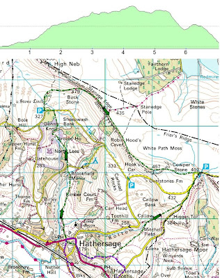
Proposed A walk from Hathersage 8th March 2008
'A' Party walk
Leader Jenny Matthias
Distance 9.5 miles approx

Leader Jenny Matthias
Distance 9.5 miles approx

Click on map and pictures to enlarge.
This is not a particularily arduous ‘A Walk’.
It starts with a steady climb from the village 179m (Approx 590’) up to Stanage Edge at 430m (app1420’), a rise of 251m (app 830’) passing North Lees, thought to be the inspiration for Mr Rochester’s House in Jane Eyre.  Then along the Edge, the highest point being ‘High Neb’ 458m (approx 1511’), until it peters out. This can be bleak and rather boggy but you can spot
 Sheffield to the east and the Ladybower Reservoir to the west.
Returning under the edge are signs of the quarrying that went on and millstones, in various stages of preparation lie scattered around. Then down Perssiel Woods and ‘Bronte Cottage’ along Baulk Lane 
Please note there are eleven styles of three different types to cross – and some places may be boggy.
If there is time the church and church yard are worthy of a visit – to see ‘Little John’s Grave’.
Proposed B walk from Hathersage 8th March 2008
Walk leader Bill Farr
Distance 7.3 miles
Ascent 1489 ft
A very nice 'middle walk', crossing over some of the A & C walks, but not clashing and giving a variety of views and experiences.
The walk has a steady ascent out of Hathersage up Baulk Lane towards 'North Lees', then around the stone circle to open land and Stanage Edge. On the Edge we walk South towards Cowper Stone and Burbage Rocks before descending to Callow and above Dale Bottom to perhaps joining hands with the C party as we return to Hathersage
Proposed C walk from Hathersage 8th March 2008
A Party walk.
Leader: George Mann
Distance: About 6 miles gently climbing to around 900 feet.
Leader: George Mann
Distance: About 6 miles gently climbing to around 900 feet.
A pleasant 6 mile walk from the town along the riverside to Grindleford then on pavment to the station. A track climbing gently then takes us up through Oxhay Woods to Booths Edge where after a short road section we join a farm track leading over fields then down through woods into Hathersage.
Subscribe to:
Posts (Atom)


