Wednesday, 18 November 2009
Walk Leaders Meeting
Tuesday, 17 November 2009
Festive Walk and Meal to end the 2009 Season
Saturday 9th January
2010
this will be followed by a special meal at the
Dog and Partridge
The coach will leave the 'Short Stay' car park behind Iceland at 0800hrs as normal
For spaces (waiting list), contact Shirley.
to view last years celebration at the same venues, click here
Photographs of the walks at Slaidburn
 B party enjoying the sunshine at the start of the walk.
 On the way up to Easington Fell.
 A fine catch by the shooting party that we passed several times.
 A pause as we near home to admire the view.
 A 'moody' sky as the sun bursts through.
 The B Party stop for a group discussion?
Hey our photograph is wanted, better put our best side forward.
 We are still enjoying ourselves despite the mud.
Monday, 19 October 2009
November Walks from Slaidburn
Saturday 14th November
There will be three walks;
 Please note that Slaidburn like the rest of the country has had a lot of rain, which is lying on the clay and peat soil. On 2nd November the ground was very, very wet. Please ensure that footwear is in good condition and wear gaiters if you have them
Slaidburn is a village and civil parish within the Ribble Valley district of Lancashire, England.
Historically a part of the West Riding of Yorkshire, Slaidburn lies near the head of the River Hodder, within the Forest of Bowland, an Area of Outstanding National Beauty.
The civil parish of Slaidburn shares a parish council with Easington, a rural parish to the north of Slaidburn.[2]
Farming is still a major employer, but the area attracts tourists – for walking in particular.
The parish church of St Andrew has a superb Jacobean screen and a fine Georgian pulpit. The brass band composer William Rimmer (1862-1936) composed the now-popular march, named Slaidburn after the village, for the Slaidburn Silver Band. A new village hall has opened to much fanfare and is being well used and of course we all know the hostelry 'Hark to the Bounty' the venue for many of our Christmas Meals, the last time being in January 2007 (but not this year).For more information about Slaidburn's historic buildings and heritage, look at this description but note this is not one of the walks.

A Walk from Slaidburn
Distance 11.5 miles
Total Ascent/descent: 1200ft

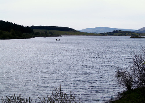 At the car park we pick up a circular route around the reservoir, firstly through woods then rising to moorland passed New House (a ruin!) onto another farm track for Catlow Farm. We leave this briefly to take a path by the brook, Parks Clough Beck. Rejoining the farm road we follow it to the Bentham Road. Here there is about a mile and a half of road walking, mostly uphill! Finding a path again we head in a SE direction towards Croasdale Farm. A little way along the farm road we take the footpath across the fields with at least five stiles, sheep and cows until once more we reach the Bentham Road near the Bridge and we arrive back in Slaidburn.
B Walk from Slaidburn


Distance: 8 miles approx
Total Ascent/descent: 1140ft
Route Map:


We have a short steep climb out of the village with a good view of the valley. As we come over the brow of the hill, we catch sight of Easington Fell, then Broadhead Farm.
 From hear it is a steady but not steep climb upwards through Skelshaw and then Fell Side, which seems to be shooting hospitality Farm with some unusual vehicles for traversing the landscape. We shall not be needing them.

The track continue around the side of Standridge Hill heading towards ‘Old Ned’ changing to a peaty walk on the last leg.
At ‘Old Ned’ we can survey and recognise a large variety of landmarks. Our way back is across open moorland to a faint track which opens up to an overgrown cart track across the moor passing a tarn. This may very well be very wet and boggy. As we continue downhill our views change and even in very heavy rain we had dramatic views

We head towards

If the river is still flooded then we will walk along the minor road past Easington and back over Whiteholme to Slaidburn
Thursday, 15 October 2009
C Walk from Slaidburn
Distance: 6 miles
Total Ascent/Descent: 502 ft


Hark to Bounty - The Hark to Bounty is one of the oldest surviving buildings in the village, dating back to the late 16th century. From about 1590 it was the site of the Halmote Court for the Forest of Bowland - the local court at which minor disputes were settled. The Inn was originally known as the 'Dog Inn'. It is said that the present name was given by the Rev Henry Wigglesworth in the mid-19th century. One day he heard the distinctive sound of his favoured dog barking among a pack of hounds, and exclaimed to his companions, "Hark to Bounty".


Monday, 14 September 2009
October Walks from Betws-y-Coed
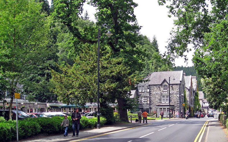
Our Walk this month will be from Betws-Y-Coed in Snowdonia National Park, North Wales
on
We last visited Betws-y-coed in April 2007, when we had a lovely day.
There will be three walks;
- A Walk led by Jenny Matthias - pending
- B Walk led by Bill Farr
- C Walk led by Norman Jones
For information about Betws-y-coed click here
Weather forecast for Betws-y-Coed
B Walk details (Betws-y-Coed)
Distance: 8 miles
Ascent: 1000ft (total ascent: 1300ft)
 click on individual pictures to enlarge.

 The steep climb then begins (approx 45 mins) through the wood to reach Llyn Elsi Reservoir with wonderful views over Snowdonia
.

From Llyn Elsi the walk is over rolling countryside to the abandoned village of Rhiwddolion on the Roman road of Sarn Helen, before descending to the Miners Bridge (A5) from where we follow the riverside path back to Betws.

A varied walk, lovely views, with one steep climb on a path to be walked with care.
C Party Walk Details
 click on map to see bigger image
Walk Leader: Norman Jones
Distance: 5.5 miles
Total Ascent:380ft
A riverside walk along the Afon Llugwy to the Swallow Falls. We start at Pont y Pair Bridge and remain close to the river as far as the Miners Bridge. The path to this point and on the later section to the Swallow Falls,is sometimes stoney,often spread with tree roots and will be muddy in places after heavy rainfall.
At Miners Bridge we have a short,130 yards, steep climb up to a minor road. We are on this for a little over 1/2 a mile before going off road for the undulating path to the well known Swallow Falls. Our return journey is the walk in reverse


Saturday, 12 September 2009
B Walk Photographs Bala
 After a steepish climb out of Bala through the woods, the ascent levelled off and it was pleasant walking with all round views and a bit of humour as one or two decided to fall into a narrow stream.
 .
. soon out of the woods and looking back at Bala
 There were one or two stiles to negotiate.
 The party after lunch prepare to move off.


