Saturday, 23 June 2012

July Walks to Glenridding (330)

Our next walk will be in the beautiful area of Cumbria around 
Ullswater and Glenridding
on
Saturday 14th July 2012
0800hrs prompt from short stay car park


Glenridding is a village located at the southern end of Ullswater, in the English Lake District. The village is popular with mountain walkers who can scale England's third highest mountain, Helvellyn, and many other challenging peaks from here.Each year, on Easter Monday, a duck race is organised by the local mountain rescue team to raise funds.

Greenside lead mine; Above the village, at Greenside, is the site of the largest lead mine in the Lake District. Lead ore was discovered in the 1650s and the site was mined from the 1690s to 1962. Without the mine, the houses and economy of Glenridding and the surrounding area would not have existed.
There will be three walks;
Details of the walks will be added as they become available, but by Saturday 7th July 

A Walk at Glenridding 2012

Walk Leader:  Tony McDonald
Total Distance: 11.5 miles
Total Ascent/Descent: 2070ft

 A Walk Pooley Bridge to Glenriding

A Route marked in red
  The walk starts just north of Pooley Bridge, and cuts through a farmer's field to an old historical settlement, and heads up towards trees which marked the boundary of the ancient settlement. The walk then enters a central Pooley Bridge which is a delightful little village, and heads towards the mountains behind Ullswater. The walking is not particularly difficult and generally on footpaths. The route goes away from the lake and reaches an altitude of 370 metres. The view from this vantage point is absolutely magnificent. There is a significant number of changes of terrain and scenery and some of the most beautiful views possible in the Lake District because of the advantage of being slightly raised above the lake the sunlight shines against a lake surface bringing the most delightful reflections. The major advantage of this walk is the tranquilly, because of the mountains to the left of the walkers. There are wonderful plants and wild birds, we also saw foxes and other mammals. About a third of the way round the track takes the walkers close to the lake again and there are stunning mountain views all around, we pass near the village of Howtown and Martindale towards Patterdale, from Patterdale along the main road to Glenriding. In terms of difficulty the walk id not particularly difficult and most A or B walkers should have no difficulty. The total distance is 11.5 miles and there is a good pub at the end of the walk! 

B Walk at Glenridding 2012

Walk Leader:  Beverley Kelly
Total Distance:8 Miles
Total Ascent/Descent: 2100ft

B Linear Walk - click to enlarge
 
We are right in the centre of the mighty peaks of the Helvellyn Range with wonderful views and challenging ascents, yet you do not need to be a mountain goat to be part of this wonderful panorama. Today we are doing an A to B walk gently rising ( see the elevation image over) with great views all the way, even if it is wet as it was on the reccie.
We alight alongside Ullswater by  Yew Crag ( so have your boots on), and ascend through woods below Gowbarrow Park. As we exit the woods we can see Lyulphs Tower, an 18th century castellated Gothic Folly built by the Dukes of Norfolk.
We soon reach Aira Force, a 20m crashing cleft with dainty footbridges above and below. We will descend to the bottom and enjoy the spectacle before climbing the steps back to our route above Glencoyne Park.

 We continue to ascend on a reasonable pathway with wonderful views to Place Fell, up the lake and beyond (weather permiting).
Through the wall and we are on the Miners Path ‘clinging’ to the side of Birkett Fell—narrow but not dangerous and quit peaceful. Watch out for the wildlife.
 Passing the cliffs of Glencoyne Head we meet the path from Sheffield Pike and so the next bit will be familiar to those who joined us last year. We are descending now, past the mines to the weir below.


Crossing the beck our return is via the lower slopes of Birkhouse Moor with views across the valley and into Glenridding, our destination and refreshment venues. 

Addendum from Mark Richards 'Far Eastern Fells';


Birkett Fell was so named in 1963 in memory of Lord Birkett of Ulverston. Norman Birkett was brought up in a strong Methodist family, the bedrock of a man of compassion which underpinned a distinguished legal career. His love of Lakeland made him an impassioned fighter on its behalf. His crowning triumph was to avert the plan to convert Ullswater into a reservoir. The inquiry ended little more than a week before his death. Such threats never really go away and a guarded vigilance is always needed. The summit cairn is composed of stones brought up from the shores of the lake by members of the Outward Bound School. There is a further memorial to Lord Birkett set on Kailpot Crag on the shores of Ullswater, with the simple inscription

He loved Ullswater,
He strove to maintain its beauty for all to enjoy.’

C Walk at Glenridding

Leader: Marion Young
Distance: 6 Miles approx
Height Gain/Descent:690ft

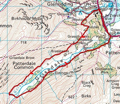
C Walk Route [anticlockwise]

This a walk we did last year, with John Smith. After looking at various alternative I could not find any thing more suitable without much more climbing involved. Therefore I repeat John's description and photographs.
 Unfortunately,  it is difficult to walk out of Glenridding without going upwards other than along the main road and upwards is something that this walk along the Grisedale Valley has in the early part after which it is a gentle stroll along either side of the Grisedale Beck. 
Greystones Coffee House and Gallery

We will start from the coach park, after the obligatory coffee stop of course, walking up the lane for some 400 yards.   Moving into the woods, the path is a slow climb up steps which we will take at the pace of the slowest and resting as often as you like.  The group will take a rest before walking along the slope up to Lanty’s Tarn.  
Lanty's Tarn
The path emerges to a fine view of the valley which we will be able to keep as we walk through a short wooded  section to descend onto the track that leads to Grisedale Tarn.
Nethermost Pike, Dollywagon Pike and Helvellyn from the entrance to the Grisedale Valley
The walk continues along this path with further views all around to a bridge which we cross to take the path home now walking towards Patterdale where we meet the main road and turn left for the final 15 minutes into Glenridding. 

Friday, 1 June 2012

June Walk[329] from Howarth

Our Walk this month will be from

Haworth

in the heart of West Yorkshire's Bronte Country

and will be on

Saturday 9th June

Morris Dancers in 2004

 Haworth is a hilltop village not far from Bradford in the heart of West Yorkshire's Bronte Country.

Situated above the Worth Valley amid the bleak Pennine moors, Haworth is internationally famous for its connection with the Bronte sisters, who were born in Thornton (near Bradford), but who wrote most of their famous works while living at the Haworth Parsonage (which is now a museum owned and maintained by the Bronte Society), while their father was parson at the adjacent Haworth church.

There will be three walks as usual;
More details about Haworth can be found here.
Weather Forecast for Haworth [next 5 days] here:

Photographs taken on these walks would be welcomed to be added to our walk log. Please send as soon as possible after the walk to the administrator.


A Walk at Haworth 2012

Walk Leader:  Peter Hitchcock
Total Distance: 12.1 mls
Total Ascent/Descent: 1840ft

A Walk Route

HAWORTH, home of the Brontë sisters, is a delightful cobble-street village in the heart of West Yorkshire Brontë country. It is surprisingly twinned with Mach-Piccu! The Brontë sisters, Emily,
Anne and Charlotte, were born in Thornton, Bradford, before moving to the Parsonage, Haworth, where Patrick Brontë, the father, was vicar. Family life was full of tragedy and Patrick outlived his son, 5 daughters and his wife. This walk takes you through some of their favourite spots – The Brontë Falls and Top Withins where a ruined farmhouse is said, by some, to be Wuthering Heights!

From the coach car park, an initial ‘b’-line to the Parsonage will take you in 5 mins to a decent toilet stop! [the rest of the walk necessitates ‘natural’ breaks’]! We head out past ‘Hathaway’ Cottages and ‘Wuthering Heights’ pub - literary licence at its best! A gentle climb then descent takes you to Lower Laith reservoir where we cross a very well-maintained dam. After a short stroll thru’ the village of Stanbury we start a gentle climb up onto Stanbury then Wadsworth Moors. The path is good stone track for most of the day involving stretches of the Pennine and Millenium Ways BUT, dependant on the weather, it is now that you could begin to feel strong freshwinds in your face for a couple of hours. 

 A decent pace is required to reach the derelict but quaint remains of Withins Height within 2 hrs then on the top of the moor where, if the visibility is clear, marvellous panoramic views of Yorkshire and Lancashire can be had. The turn-round point will depend on time/pace but, hopefully, a quick glimpse of a blaze of rhododendron bordering 


Walshaw Dean reservoir will be worth the effort before returning to Haworth via the Bronte Way, Bronte Bridge and Bronte Falls - a delightful, romantic setting if the sun is shining! The route is a good ‘hike’ of about 14 miles but eased by generally solid tracks and gentle contours.

Return to the coach with an impressive wind or sun tan!


B Walk from Haworth 2012

Walk Leader: Gwyn Jones
Distance: 8.5 mls
Total Ascent/Descent: 1200/960ft

Click to enlarge
B Linear Route to Haworth [click to enlarge]


A linear walk starting at Laneshaw Bridge and ending at Haworth. Although this walk has its ups and downs there is nothing too severe. The only real pull is fairly short. A GREAT DEAL OF IT IS ON THE Pendle and Bronte ways. To start we head to the very pretty village of Wycoller, then head gradually up onto the moors. 

Wheatear on Dove Stones Moor
We pass alongside two reservoirs and the village of Stanbury. We drop down to cross a third reservoir before a gentle climb towards Haworth. 
Water Sheddies Reservoir
Ponden Reservoir
 (I suggest you get booted up before the coach drops us off in Laneshaw Bridge so you can leave your shoes on the coach and don’t have to carry them.)