Showing posts with label Hollingworth. Show all posts

Sunday, 20 October 2013

344 November Walks from Hollingworth

Our next walking will be from the Weighver's Seaport near Rochdale, just an hours drive away, yet with some great walking country around
it is

Hollingworth

and will take place on

Saturday 9th November 2013
0800hrs prompt from short stay car park in the village
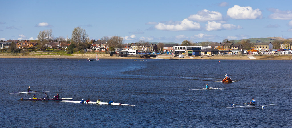
Hollingworth Lake in summer
Hollingworth Lake is a 130-acre (53 ha) reservoir at Smithy Bridge, in Littleborough — part of the Metropolitan Borough of Rochdale, in Greater Manchester, England. The lake was originally built as the main water source for the Rochdale Canal, but developed as a tourist resort from the 1860s, and became known as the Weighver's Seaport. Hotels were built around it, at least two of which had outdoor dancing stages with gas lighting. Tourism was helped by the arrival of the railway in 1839, which brought day-trippers and weekend visitors from Manchester, Bradford and Leeds.

The popularity of the lake as a resort declined in the early twentieth century, and the area was used as an army camp during the First World War. The canal company sold the reservoir, with seven others, to the Oldham and Rochdale Corporations for water supply in 1923, by which time the canal was in terminal decline. After the Second World War, boating rights were bought by Rochdale Council, who developed the area into the Hollingworth Lake Country Park in 1974. There has been a steady increase in facilities since, and it is now a thriving centre for water sports and other activities.

The lake was used for training by Captain Matthew Webb, before he became the first man to swim the English Channel in 1875, and was used for the "World Professional Mile Championship", a long-distance swimming event, in the 1880s. It is home to the Hollingworth Lake Rowing Club, which has been in continuous existence since 1872. 
There will be three walks;
Details will be added as they become available, but by Saturday 2nd November 

Saturday, 19 October 2013

A Walk from Hollingworth Visitor Centre 2013

Walk Leader: Tony McDonald
Distance:  10+ miles approx  
Total Ascent/descent: 1650ft


Awaiting details

B Walk from Hollingworth Visitor Centre 2013

Walk Leader: Beverley Kelly  
Distance: 8 miles approx
Total Ascent/descent: 1300ft


Aiggin Stone and the Weighvers Way


B Route anticlockwise


This walk is a repeat of the 2010 walk which was so successful because of its variety of terrain and views. We walk through woods, across a golf course, on a Roman Road; discover a 600yr old landmark, rescued animals and a relaxing stroll along the restored Rochdale Canal, the only thing missing from last time may be the beautiful crisp snow but hopefully we will have the brilliant sunshine to make the grasses glow.


Leach Hill and Higher Chelburn Reservoir


We shall be ascending past the Visitor Centre, where I have been assured that the wardens will let us use the toilets when it opens at 9.30am, before traversing the pathway through the trees towards Littleborough. 
At some steps we ascend through more woods towards the golf course and alongside it, not stopping at the 19th hole! to reach the Rochdale Way.


Near the road we pass alongside some delightful old cottages and continue the gentle climb up and as it gets a bit steeper we encounter the Roman road, complete with drainage channel, which climbs to the Aiggin Stone and Blackstone Edge (and beyond). Look for the Latin cross and the letters I & T on the Aiggin Stone 

We now cross moorland towards the White House, crossing the Broad Head Drain just before we meet the Halifax Road, then head towards the Chelburn Reservoirs, down a bleak valley, past a farm looking after rescued animals, which used to have a warning that somebody!!! would be shot if the animals were fed!!! This thankfully has gone.

A short climb to Leach Hill where we have a lovely view of this high valley before descending to Summit and the canal. This may be our lunch spot if we can last out this long? 


From Summit it is then a pleasant 1.5 mile stroll downhill along the Rochdale canal and several locks to Littleborough and a return back via a good pathway which you will recognise towards the visitor centre at Hollingworth


C Walk at Hollingworth Visitor Centre 2013

Walk Leader: Les Gibson
Distance: 6 miles approx  
Total Ascent/descent: 600ft

C Route anticlockwise

The ‘C’ walk starts after coffee etc. at the visitor centre, with a walk around the lake enjoying the lovely views across the lake, and the many different types of aquatic birds. We then make a small climb up and over Benny Hill !! which leads to the Pennine Way, which affords us with some beautiful scenery, weather permitting. After leaving the Pennine Way we make our way to the canal which leads us back ( via a bit of mud! ) to the visitor centre for further refreshments. There are no stiles on this walk.


Wednesday, 3 March 2010

March Walks from Hollingworth Visitor Centre, nr. Rochdale

Our first walk of 2010 will be from a new venue high up in the pennines, providing wonderful views with the least effort and should be a good warm up for our season of walks. Gwyn is taking bookings now so be sure to get yourself on the coach. Membership fees (£10) are also now due.
Our first walk will be on;

Saturday 13th March 2010

There will be 3 walks;
Details will be added as they become available but by 6th March

Hollingworth Lake was construsted as a feeder source for the Rochdale Canal and was completed in 1800.
Around about 1850, James Sladen, an engineer at Newall's woollen mill in Littleborough, obtained permission from the then owners, Rochdale Canal Company, to put two small steamboats on it but the venture was unsuccessful. Gradually, the lake became more popular, seven hotels with large ballrooms and pleasure grounds which rivalled Manchester's Belle Vue were built. At the height of its popularity there were three lake steamers. 
Known as the Weighver’s Seaport, it became very popular in the mid-19th century, when connected by railway to Manchester, Leeds and Bradford. Several hotels were built, including, the Beach Hotel, the Lancashire and Yorkshire Hotel and the Lake Hotel on the far side which was accessed by steam launch. Currently there are two public house located next to the lake, the Beach Hotel and the Wine Press.
During the First World War there was a large training camp in Ealees Valley. After that war, the lake became less popular for holidays and the tourist facilities declined.
In 1950 Rochdale Council took over the boating rights from the Water Board which had acquired the lake from the canal company. In 1974 plans were approved to make the area a country park. It is now used for recreation and includes a wildlife sanctuary.


Boats on Hollingworth Lake


Hollingworth Lake and Littleborough from Clegg Moor

A Party Walk from Hollingsworth


Leader: Tommy Ryder
Distance: 8-9 miles
Height Gain: 1430ft


An excellent walk to start the year, The walk along Pennine Bridleway opens up as we head towards the radio mast. We then cross the foot bridge over the M62 and climb up Clegg Moor. The walk over Blackstone edge is then greeted by the fantastic views overlooking Littlebough and surrounding Moors. We then walk down the Roman Road towards Lydgate and over the Golf course taking in some excellent views, then a short walk back to the visitor centre for a cup tea and cake.


B Party Walk from Hollingsworth Lake

Click on any image to enlarge for viewing

Leader: Beverley Kelly
Distance: 8 miles
Height Gain:1400ft

We were blessed with a lovely day for the reccie, with fresh crisp snow on the upper parts and beautiful sunshine in the afternoon. The snow may not be there on the day but the sun may be!
All three parties will be ascending past the Visitor Centre, where I have been assured that the wardens will let us use the toilets, before traversing the pathway through the trees towards Littleborough.

At some steps we ascend through more woods towards the golf course and alongside it, not stopping at the 19th hole! to reach the Rochdale Way.
Near the road we pass alongside some delightful cottages and continue the gentle climb up and as it gets a bit steeper we encounter the Roman road which climbs to the Aiggin Stone (and beyond).

As it was deep snow we could not find the path to the White House, so we ascended back to Broad Head Drain, where we met a lovely couple who walked with us, alongside the drain to the White House.
We now head towards the Chelburn Reservoirs, down a bleak valley, then past a farm looking after rescued animals, with a warning that somebody!!! would be shot if the animals were fed!!!

At Leach Hill we have a lovely view of this high valley before 
descending to Summit and the canal.
It is then a pleasant 1.5 mile stroll along the canal to Littleborough and a return back via a good pathway which you will recognise towards the visitor centre at Hollingworth

C Walk from the Cafe at Hollingworth Lake

 
click on map (and pictures) to enlarge.
C Walk
Leader:          Norman Jones
Distance:       6.5 miles
Height Gain:  400ft
 
After refreshments, it's a short lakeside walk to pass by the Visitor Centre, then a path through woods and alongside a stream. The path climbs upwards passing a golf course and joins the Rochdale Way bridle path. We go south for a little over two miles on the lower part of Clegg Moor.   

A footbridge enables us to cross the M62 motorway without everyone holding hands and making a dash for it! The route then winds generally downwards and turns to take us back under a motorway viaduct for our return to the lakeside road and refreshments.

In general the paths are not too bad, but may be muddy and slippery on the gradients. there are extensive views from the moor, weather permitting.