Welcome to the Holy Trinity Fell Walking Club in the village of Formby!
Get your boots on and join in the fun.
Walking on the Second Saturday March to November
Three Graded and Tested Walks - Coach Transport from Formby Village
For a walk in mud, mud, glorious mud! At least that is what we met in the recce. Not that it did much for the complexion but what better way to work up an appetite. Leaving Chipping at the start of this six and a half mile walk along Church Raikes we go up and over the moor past Windy Hill to the ruins of High Barn (was it blown down?). Following a farm track in an easterly direction over stepping stones to Lickhurst Farm where the dogs bark loudly and the farmer is a wit. Running the gauntlet at the flocks of pheasant to Knot Hill, where there is am old quarry. Then more mud, strange bridges with funny stiles and finally the road back into Chipping. I should mention there are a few stiles which get slippery with the mud!
If it is clear we will see the Bowland fells, Longridge and of course Pendle if not we will be ready for the end of the road!!
We start off on the road making our way through the town then branch off this to a farm road then cross fields to Knot Hill. From there we make our way up through Lickhurst Farm to pick up a farm track leading to High Barn.Then if underfoot conditions are acceptable over fields to Windy Hill, and Birchen Lee and across fields to the road past the old chair factory and the coach park.
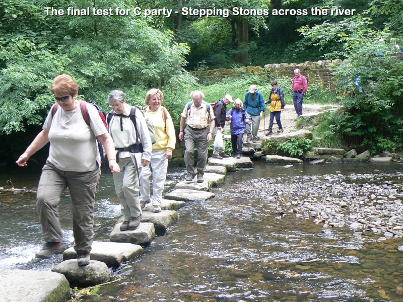
The “C” walk today is by popular request a repeat of last years walk which is more like a stroll, just enough to work up an appetite for a good lunch.
From the coach park we will take a leisurely stroll through Chipping village taking in coffee at the Cobble Café. Then on mainly dry paths with a couple minor ups and downs to walk a 4mile circular route back into Chipping.
If you have not already booked your place, then please contact Shirley as soon as possible
Chipping is situated in the Ribble Valley on the edge of The Trough Of Bowland.
A well kept secret to many, This picturesque Lancashire village has won a number of best kept village competitions over the years.
The village is known to be at least 1,000 years old and is named
in the Domesday book as 'Chippenden' the name coming from the
medieval 'Chepyn' meaning market place. Chipping really thrived
during the Industrial Revolution when there were seven mills
located along Chipping Brook. Today only one survives the famous
chairmaking factory of H.J.Berry where furniture has been designed and
made since the 1890’s.
The
Trough Of Bowland is both a delight and a pleasure with its
rolling pastures, working farmland and dense forestry. The area is
classed as “an area of outstanding natural beauty” and it
certainly lives up to expectation. The
Forest of Bowland occupies most of the north east of Lancashire. It
consists of barren gritstone fells, deep valleys and peat moorland. It's
an attractive alternative to the overcrowded Lake District, and today
this grouse moorland is also used for walking and cycling. The name 'forest'
is used in its traditional sense of 'a royal hunting ground', and
much of the land still belongs to the Crown. In the past wild
boar, deer, wolves, wild cats and game roamed the forest. The origins of the name Bowland most likely came from the long-standing connection of the region with archery - the 'land of the bow'.
Just to the North of the village the access areas of Clougha, Fair Snape, Wolf Fell and Saddle Fell have been opened up to the public by access agreements
negotiated between Lancashire County Council and the owners. This
means that over 3,260 acres of open country is now open to walkers.
Due to an administration error[not of our doing] the coach did not arrive on the 12th November and thus the 'official walk' did not materialise, although some unofficial walks did take place around the lovely Formby sand dunes. The walk to Uppermill has therefore been rescheduled to be our first walk of the 2012 season onSaturday 10th March 2012 ______________________________________
Our first walk of the season will be in the delightful rolling hills of Saddleworth, an area of much community culture and friendly welcomes
Uppermill
near Oldham and will take place on
Saturday 10th March 2012
0800hrs prompt from short stay car park in the village
The small town/large village of Uppermill is on the northeast side of Greater Manchester is a popular stop for visitors to nearby Saddleworth and has a growing number of craft shops, restaurants and cafes to cater to the tourist market. We last visited Uppermill in June 2008 [see the link to the right.
Saddleworth is a group of villages and Hamlets North East of Manchester, United Kingdom. The nearest town is Oldham in Lancashire of which Saddleworth is currently a part of, although the popular tourist spot was once a part of the West Riding of Yorkshire until about 1974.
Tucked away in a valley of the Pennines on the Huddersfield Narrow Canal, it is in a most picturesque location on the high moorland. Once inhabited by the Romans, like many Lancashire towns it was the Industrial Revolution which had the most impact on the area, with the building of huge textile mills. The area also supported some quarrying and the Ladcaster and Den Quarries to the west of Uppermill are now designated Sites of Special Scientific Interest for their geological features.
One unique local sport played in Uppermill is “cobbling”. It involves a barrel of cobblestones, a closed road and a bag of cement. You will have to visit to find out more!
More cultural activities are centered on the local Saddleworth Museum which highlights Roman activity in the area. The museum has a local art gallery exhibiting paintings of local landscapes, transport and industry in the area. The Brownhill Countryside Centre is a small museum aimed at educating children about local wildlife and has a lovely wildflower garden.
The canal which runs through the town offers many recreational pursuits. Traffic-free walks along the towpath, fishing and boating are just some of the rural pleasures to be enjoyed. The canal has a couple of locks to manage the inclines and there is an impressive viaduct which it passes beneath.
Uppermill hosts a number of festivities each year, the highlight of which is the Saddleworth Folk Festival. The Brass Band Contest and the Beer Walk take place at the end of May and there is always a theme for the event.
More cultural in its origins is the Rushcart Festival at the end of August, when teams of Morrismen arrive from all over the country to compete in pulling a rushcart with a jockey sitting on top. The route takes them through the local villages of Saddleworth, Greenfield, Delph and Dobcross where the Morrismen stop and give a performance of their ancient English folk dancing. The following day there are gurning (face-pulling) contests, wrestling and worst singer competitions and a merry time is enjoyed by all!
Saddleworth is rolling countryside and valleys, so there will be plenty of 'ups and downs' giving variety and pleasure. Details of the walks will be posted here about 1 week beforehand.
The coach will park by the Swimming Baths just up the hill from the village centre, approx 10 minutes walk. The toilets are in the park at the centre of the village.
Our next walking will be from a charming village right in the heart of the Lake District National Park in Cumbria, and was once the home of the famous poet William Wordsworth. Famous for Gingerbread and William Wordsworth, it has been a regular venue for the club because of its wonderful views, variety of walks shops and refreshment venues. It is
Grasmere
and will take place on
Saturday 8th October 2011
0800hrs prompt from short stay car park in the village
Helm Crag in Autumn
The village is on the river Rothay which flows into the lake Grasmere about 0.5 km to the south. The village is overlooked from the NW by the rocky hill of Helm Crag, popularly known as The Lion and the Lamb or the Old Lady at the Piano. These names are derived from the shape of rock formations on its summit, depending on which side you view it from.[2]
A number of popular walks begin near the centre of the village, including the ascent of Helm Crag and a longer route up to Fairfield. The village is also on the route of Alfred Wainwright's Coast to Coast Walk.[3]
Grasmere Village
The A591 connects Grasmere to the Vale of Keswick over Dunmail Raise to the north, and Ambleside to the south. In other directions, Grasmere is surrounded by high ground. To the west, a long ridge comes down from High Raise and contains the lesser heights of Blea RiggSilver How. To the east, Grasmere is bordered by the western ridge of the Fairfield horseshoe. and
We will leave the car park and make our way through the village of Grasmere.This ia your chance to assess the merits of the various watering holes for our return!Taking the Easedale Road - hoping it doesn’t lull you into a false sense of comfort - for a mile or so before we start the zig zag climb up onto Helm Crag.This is sometimes referred to as ‘The Lion and the Lamb” because of the rock structures.On a clear day you can see as far as Morecambe Bay.
We will continue along the ridge over Gibson’s Knott, Pike of Carrs to Calf Crag - Part of the ‘Coast to Coast walk’ - before dropping down off the ridge.
We will then climb up onto Greenup Edge, the ridge dropping down into Borrowdale.
We will then begin our descent into Far Easdale back into Grasmere.
This quiet valley, little changed from Wordsworth’s day, a pleasant end to a fairly energetic walk.
Our walk today involves a stiff climb to a great vantage point which is also one of Wainwrights peaks, a stroll uphill to another Wainwright peak, our highest point where we can look down upon lakelands biggest tarn and the start of our descent back down to Grasmere.
The Langdales from Silver How
The walk starts to the north of the village where we head uphill towards Allen Bank, once home of William Wordsworth, which we circumnavigate up a track. Already we are having great views of this beautiful valley and the massives surrounding it. As we come out above the trees the walking is easier and views better and it is probably time for our first rest before we cross Wray Gill and head for the gentle summit of Silver How.
Sleepy Grasmere from Silver How
After the photo shoots and the oooh's and aaah's we head westward across this broad ridge which starts at High Raise, the central peak of the lakes. Passing Youdell Tarn it is a bit boggy but a wonderful panorama as we pass the peak of Lang How then Swinescar. As we approach Little and Great Castle How the ground is more rocky and interesting, particularly for geologists. If we have made good time we will head for Blea Rigg which is a good lunch stop, looking over the Langdales and Crinkles [add 150ft climb].
Easdale Tarn near where we descend from just before Blea Rigg
After lunch we retrace our steps a bit to descend on an unclear pathway down to Easdale Tarn, a popular venue for many tourists following in the footsteps of Wordsworth. The ascent was popular during the Victorian period, and a refreshment hut was even established in the 19th century by Robert Hayton of Grasmere above the outlet of the tarn to service the thirsty visitors. The hut is long gone, and nettles now grow where the ruins used to be.
A group of visitors at Easdale Tarn
Our descent now is on a restored pathway all the way down back to Grasmere, but the delights are not over yet for we are alongside the rushing 'Sourmilk Gill' as it tumbles over a couple of waterfalls and we are now looking towards the Fairfield and Helvellyn ridges and memories perhaps of previous walks.
Sourmilk Gill in full flow
There will be many a cheerful greeting as we continue on our descent, enjoying the autumnal colours and the thought of refreshments at one of the many teashops and hostelries in Grasmere. Given the weather this is a lovely Fell Walk and even in bad weather we are protected and should be below the cloud line
On Blea Rigg Summit, a lovely lunch spot.
Thanks to Les Gibson who accompanied me on the reccie.
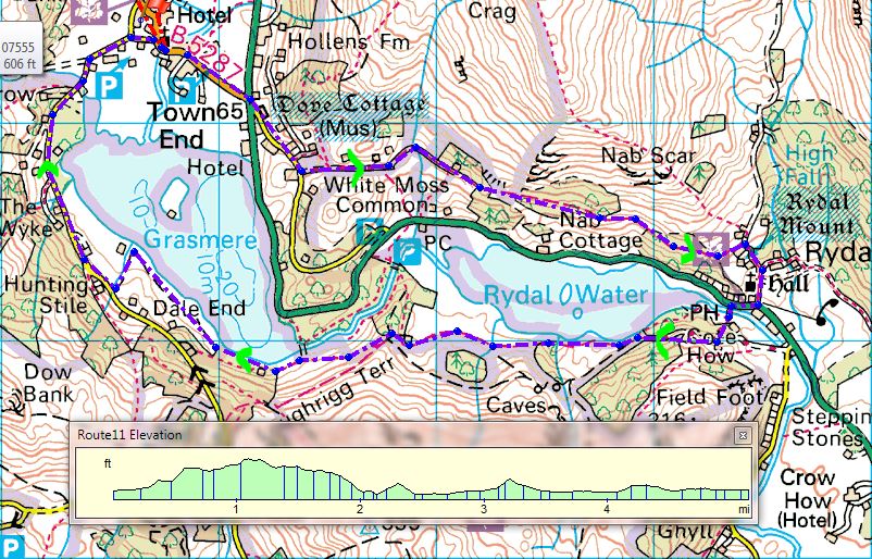
The walk leaves Grasmere in the direction of the A591. After crossing the main road the walk ascends to meet the ‘Coffin Trail’ and continues onwards to reach White Moss Common. High elevation views of Grasmere can be seen on this section. The walk continues along a bridleway to eventually approach Rydal Mount.
Rydal Mount
A slight descent towards the A591, to re-cross the road and access the narrow bridge opposite, before turning in the general direction of Grasmere.
The walk continues into a wood keeping Rydal Water just to the right, eventually ascending to reach a footpath which overlooks Rydal Water.
From this point the walk continues onwards through leafy woods to reach the lake side and then finally approach the town of Grasmere.
The Weir approaching Grasmere
The Weir
Grasmere water
A lovely cottage on the approach returning to Grasmere
Ground conditions are a mixture of footpaths, bridleways, woodland treks and minor roads. Views of interest are many and varied. There are no stiles to be negotiated but a few kissing gates and the walk is extremely pleasant.


 Just to the North of the village the access areas of Clougha, Fair Snape, Wolf Fell and Saddle Fell have been opened up to the public by access agreements
negotiated between Lancashire County Council and the owners. This
means that over 3,260 acres of open country is now open to walkers.
Just to the North of the village the access areas of Clougha, Fair Snape, Wolf Fell and Saddle Fell have been opened up to the public by access agreements
negotiated between Lancashire County Council and the owners. This
means that over 3,260 acres of open country is now open to walkers.