Showing posts with label Slaidburn. Show all posts
Showing posts with label Slaidburn. Show all posts
Thursday, 18 October 2012

Monday, 10 September 2012
October Walks in Slaidburn
Our next walk will be from
Slaidburn
in the FOREST OF BOWLAND
area of Outstanding Natural Beauty
area of Outstanding Natural Beauty
and will be on
Saturday 13th October 2012
0800hrs prompt from the short stay car park

More details about the area here
and here [pdf]
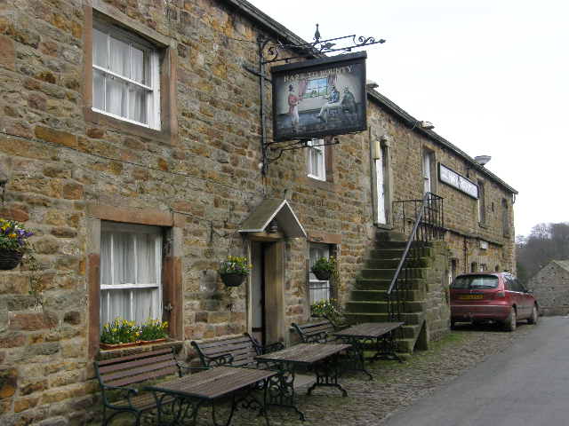
Slaidburn and its history
Visiting Slaidburn in the Forest of Bowland Area of Outstanding Natural Beauty is like stepping back in time. Isolated and protected by the surrounding Bowland fells, and largely owned by a single family for almost 200 years, the village has remained un-spoilt by modern development and is virtually unchanged since the early 19th Century.
Many have described Slaidburn as the most picturesque village in Lancashire. From the village green on the bank of the river at the eastern entrance to the village, the main street with its ancient cobbled pavements climbs gently into the heart of the village. By the post office is what looks like a sentry box but is in fact a first aid box that once contained a stretcher for injured fell walkers. A roadside well in the village commemorates the golden jubilee of Queen Victoria and there is a fine war memorial. There are few modern buildings and the village feels frozen in time. A short walk from the centre of the village takes you past the 18th century school to the Medieval Church of St Andrew’s.
Slaidburn whilst picturesque is also a living, working village still largely dependent on agriculture, with a large number of its inhabitants working in the local area.
There will be three walks as normal:
- A Walk led by: Tony McDonald
- B Walk led by: Beverley Kelly
- C Walk led by: Peter Parry
We have had a lot of heavy rain over this summer and more recently and as a result the ground is very wet and muddy. PLEASE ensure that footwear is waterproof and gives ankle support as ALL walks will encounter muddy, slippy ground and lying water. Walk leaders have taken this into account in planning the walks, but this is not a summer walk.We do not want any accidents.
Weather Forecast: The forecast is for sunny periods with light rain showers in the afternoon. Wind (5/6mph) is SW veering round to WNW and a temperature of 7/9C
More details about the area here
and here [pdf]
Sunday, 9 September 2012
A Walk at Slaidburn 2012
Walk Leader: Stuart Smith and Tony McDonald
Total Distance: 11 miles
Total Ascent/Descent: 1800ft app

Some photographs of a similar walk in 2008 here:
Total Distance: 11 miles
Total Ascent/Descent: 1800ft app

This walk is of particular
interest to me because my mother and father bought a small farm in Bashall
Eaves when newly married in 1955 which is only a short distance away from
Slaidburn and they always had fond memories of living there.
We start the walk off from Newton which was formerly known as
Newton on Hodder walking through undulating fields which have no visible path
to follow. We travel North past Crawshaw before turning West past Beatrix. Once
across the river we head North following the river through the forest and on to
Whitendale before finally turning east past Dunsop Fell and Wood House
ultimately arriving at Slaidburn.
Stuart
B Walk at Slaidburn 2012
A Lordly Route Through the Centre of England
Walk Leader: Beverley KellyTotal Distance: 8+ miles
Total Ascent/Descent: 750ft
Time: approx 4.5 hrs
 |
| B Walk Route - click to open |
 |
| Autumn colours by a tranquil Hodder |
We have done three reccies to get a walk which provides views, interest and reasonably good walking conditions. We are pleased with the result. This walk is probably the best of the three and will get you back to Slaidburn tired but satisfied and ready for your refreshment.

We start our walk from Newton, a village recorded in the Domesday book but grew due to local industry centered upon the River Hodder. Unfortunately the toilets at Newton have been closed although there are some later in the walk.
Leaving Newton we walk along the banks of the Hodder and then on to 'Giddy Bridge' and the Tudor Style Knowlmere Manor, built in 1849 for Jonathon Peel. Whether this is still part of Lord Bowlands estate I do not know, but it still looks as if it is under one ownership.
 | |
| Les with his 'catch' !!!! |

Our next destination is over rough and wet but passable land towards Dunsop Bridge, passing Thorneyholme Hall another part of the Bowland Estate and across the Hodder again and down a magnificant driveway to reach Dunsop Bridge and the centre of England. Here there are toilets, a cafe and probably our lunch stop by the river courted by the ducks.

We now head for Beatrix Fell, passing a lovely children's playground, past some cottages, then out to open fields again heading for Beatrix Farm. Do take in the magnificant views all around and enjoy the rolling countryside and the changing colours of the trees.


Looking forward to your company and a great walk together. Beverley and Les
C Walk at Slaidburn 2012
Walk Leader: Peter and Diana Parry
Total Distance: 6 miles
with 14 stiles (one or two difficult) and the odd muddy spot after rain
Total Ascent/descent: 454/486 ft


The walk, on grass footpaths and farm tracks, leads NW out of Slaidburn and climbs gently above the River Hodder, affording fine views of the Bowland Fells.

We then turn South West on undulating terrain, still with fine views, until a short downhill section on a quiet road brings us to Newton-in-Bowland.
.JPG)
A final one and a half miles along the banks of the Hodder completes the walk
Total Distance: 6 miles
with 14 stiles (one or two difficult) and the odd muddy spot after rain
Total Ascent/descent: 454/486 ft


The walk, on grass footpaths and farm tracks, leads NW out of Slaidburn and climbs gently above the River Hodder, affording fine views of the Bowland Fells.

We then turn South West on undulating terrain, still with fine views, until a short downhill section on a quiet road brings us to Newton-in-Bowland.
.JPG)
A final one and a half miles along the banks of the Hodder completes the walk
Tuesday, 17 November 2009
Photographs of the walks at Slaidburn
The sun was shining when we arrived in Slaidburn after a quick journey. The A & B parties were soon off while the C party waited for the cafe to open. We were fortunate that the rain kept off during the morning allowing some good walking in mild conditions even though the terrain was a bit tricky and despite the river being 2ft lower than 10 days ago, all walks had to adjust to avoid the worst conditions.
 B party enjoying the sunshine at the start of the walk.
 On the way up to Easington Fell.
 A fine catch by the shooting party that we passed several times.
 A pause as we near home to admire the view.
 A 'moody' sky as the sun bursts through.
 The B Party stop for a group discussion?
Hey our photograph is wanted, better put our best side forward.
 We are still enjoying ourselves despite the mud.
Monday, 19 October 2009
November Walks from Slaidburn
The walks next month will be from the well known village of Slaidburn and will take place on
Saturday 14th November
There will be three walks;
 Please note that Slaidburn like the rest of the country has had a lot of rain, which is lying on the clay and peat soil. On 2nd November the ground was very, very wet. Please ensure that footwear is in good condition and wear gaiters if you have them
For more information about Slaidburn's historic buildings and heritage, look at this description but note this is not one of the walks.

Saturday 14th November
There will be three walks;
 Please note that Slaidburn like the rest of the country has had a lot of rain, which is lying on the clay and peat soil. On 2nd November the ground was very, very wet. Please ensure that footwear is in good condition and wear gaiters if you have them
Slaidburn is a village and civil parish within the Ribble Valley district of Lancashire, England.
Historically a part of the West Riding of Yorkshire, Slaidburn lies near the head of the River Hodder, within the Forest of Bowland, an Area of Outstanding National Beauty.
The civil parish of Slaidburn shares a parish council with Easington, a rural parish to the north of Slaidburn.[2]
Farming is still a major employer, but the area attracts tourists – for walking in particular.
The parish church of St Andrew has a superb Jacobean screen and a fine Georgian pulpit. The brass band composer William Rimmer (1862-1936) composed the now-popular march, named Slaidburn after the village, for the Slaidburn Silver Band. A new village hall has opened to much fanfare and is being well used and of course we all know the hostelry 'Hark to the Bounty' the venue for many of our Christmas Meals, the last time being in January 2007 (but not this year).For more information about Slaidburn's historic buildings and heritage, look at this description but note this is not one of the walks.
A Walk from Slaidburn
Leader: Jenny Matthias
Distance 11.5 miles
Total Ascent/descent: 1200ft

Distance 11.5 miles
Total Ascent/descent: 1200ft

Although this walk is not difficult it is long and a good pace will need to be maintained because of the short day.
We will leave the car park and walk up the hill to the war memorial turning right along the Bentham Road. Over the bridge we take a footpath on the right across the fields to a farm road and cross the River Hodder up to Hammerton Hall Farm. We continue along the track to Black House Farm then we follow the farm road to Hole House Lane. Joining the road we see St James Church (rebuilt after the drowning of Stocks village for the reservoir). We follow the road for about a third of a mile. We have views of Stocks Reservoir.
 At the car park we pick up a circular route around the reservoir, firstly through woods then rising to moorland passed New House (a ruin!) onto another farm track for Catlow Farm. We leave this briefly to take a path by the brook, Parks Clough Beck. Rejoining the farm road we follow it to the Bentham Road. Here there is about a mile and a half of road walking, mostly uphill! Finding a path again we head in a SE direction towards Croasdale Farm. A little way along the farm road we take the footpath across the fields with at least five stiles, sheep and cows until once more we reach the Bentham Road near the Bridge and we arrive back in Slaidburn.
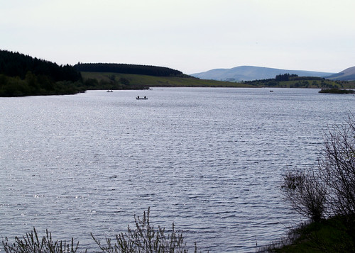 At the car park we pick up a circular route around the reservoir, firstly through woods then rising to moorland passed New House (a ruin!) onto another farm track for Catlow Farm. We leave this briefly to take a path by the brook, Parks Clough Beck. Rejoining the farm road we follow it to the Bentham Road. Here there is about a mile and a half of road walking, mostly uphill! Finding a path again we head in a SE direction towards Croasdale Farm. A little way along the farm road we take the footpath across the fields with at least five stiles, sheep and cows until once more we reach the Bentham Road near the Bridge and we arrive back in Slaidburn.
B Walk from Slaidburn


Leader: Beverley Kelly (due to the unfortunate indisposition of Les Gibson)
Distance: 8 miles approx
Total Ascent/descent: 1140ft
Route Map:


Distance: 8 miles approx
Total Ascent/descent: 1140ft
Route Map:


We have a short steep climb out of the village with a good view of the valley. As we come over the brow of the hill, we catch sight of Easington Fell, then Broadhead Farm.
 From hear it is a steady but not steep climb upwards through Skelshaw and then Fell Side, which seems to be shooting hospitality Farm with some unusual vehicles for traversing the landscape. We shall not be needing them.

The track continue around the side of Standridge Hill heading towards ‘Old Ned’ changing to a peaty walk on the last leg.
At ‘Old Ned’ we can survey and recognise a large variety of landmarks. Our way back is across open moorland to a faint track which opens up to an overgrown cart track across the moor passing a tarn. This may very well be very wet and boggy. As we continue downhill our views change and even in very heavy rain we had dramatic views

We head towards

If the river is still flooded then we will walk along the minor road past Easington and back over Whiteholme to Slaidburn
Thursday, 15 October 2009
C Walk from Slaidburn
Walk Leader: Terry Simmons
Distance: 6 miles
Total Ascent/Descent: 502 ft

We depart from the cafe near the car park after morning coffee and go through the village, passing the 'Hark to the Bounty' Pub, an old coaching inn. We carry along Back Lane, then right through woodland, crossing over Tenter Hill, through the farm of Myttons, then on towards Pains Hill Farm. Next we walk through Formby resident John Moores son's farm and the newly named Parrock Head Hall, down to Crawshaw's Farm and after 20 mins approx arriving in the village of Newton. Our route back to Slaidburn follows the contours of the river Hodder in time for a leasurely afternoon refreshments.
Hark to Bounty - The Hark to Bounty is one of the oldest surviving buildings in the village, dating back to the late 16th century. From about 1590 it was the site of the Halmote Court for the Forest of Bowland - the local court at which minor disputes were settled. The Inn was originally known as the 'Dog Inn'. It is said that the present name was given by the Rev Henry Wigglesworth in the mid-19th century. One day he heard the distinctive sound of his favoured dog barking among a pack of hounds, and exclaimed to his companions, "Hark to Bounty".
Distance: 6 miles
Total Ascent/Descent: 502 ft
Route map:
'C' route is the purple one. Click on map to enlarge

Hark to Bounty - The Hark to Bounty is one of the oldest surviving buildings in the village, dating back to the late 16th century. From about 1590 it was the site of the Halmote Court for the Forest of Bowland - the local court at which minor disputes were settled. The Inn was originally known as the 'Dog Inn'. It is said that the present name was given by the Rev Henry Wigglesworth in the mid-19th century. One day he heard the distinctive sound of his favoured dog barking among a pack of hounds, and exclaimed to his companions, "Hark to Bounty".
Subscribe to:
Posts (Atom)