Monday, 5 August 2013

341 August walks from Elterwater

Our next walks will be from

ELTERWATER

a pretty village in the English Lake District

Saturday 10th August 2013

0800hrs prompt from the short stay car park at the back of Iceland 


 Our walk this month will be from the heart of the Lakes and is a favourite area for all keen walkers and climbers. The village is only small, but is probably most famous for the Britannia in which dominates the village green and always has customers at the outside tables enjoying the clear lakeland air and views. It is also where the Judy Boyes, an ex Formby artist, has her gallery.
More details and history of Elterwater can be viewed here
 
There will be three walks:


Click for Weather Forecast for Elterwater:- 

A walk from Elterwater

Walk Leader: Jenny Mathias
Total Distance: 8 miles
Total Ascent/descent: 2000ft app

A Route anticlockwise from flag

  This walk has lots of variety and is described as 'challenging' in the Country Walking magazine. We had a beautiful, hot day to do the reccie. You we see mountains, lakes, rivers, gills and eyesores! It is a very undulating walk with some narrow paths and screes to cross.


We will leave Elterwater and climb up on to Dow Bank before dropping down through a steep path in the trees towards Grasmere. A short road walk will take us to a path skirting Silver How back on to the ridge once more. As we cross the ridge the Langdale valley comes into view showing the scar of the quarry on the far side. We follow the contour of the fell, high above Chapel Stile crossing becks and waterfalls before a sharp descent brings us to the Great Langdale road. Following the road up the valley for a short distance we join a path that takes us behind Baysbrown then the road through the quarry until we find a path to to Langdale Beck which we then follow into Elterwater.


B Walk from Elterwater

Walk Leader: Beverley Kelly
Total Distance: 7.5 miles app
Total Ascent/descent: 1400ft app
 
B Walk Route anticlockwise


An easier walk this month after last months heat wave and completing most of the ascent before lunch!


Rather than racing up Ling moor we are meandering around Little Langdale taking in some real treasures.

Out of Elterwater we take the easier climb alongside Great Langdale Beck to Chapel Stile then to wards the working quarry which we pass through, pausing to take in the view of the Langdale pikes just beforehand.

As we exit the trees we view magnificent Wetherlam and Little Langdale valley. A difficult patch here due to excessive vegetation, as we hug the side of Lingmoor for ½mile, but the views are well worth it.
 

As we wonder round Little Langdale Tarn we find our lunch spot on a naturalised slate heap and watch the world go by. Nearby is one of Lakeland's little known wonders—Cathedral Cave which you just have to see to believe. We will visit the lower cavern.

We continue along pleasant path ways, past an occasional stone cottage and with great views, as we head towards Colwith Force which on the reccie was in full flow and very spectacular.

Now out of the trees again and to wards Skelwith Force which we can see just over the fancy new bridge over the River Brathay. Here we watched two youngsters shooting the rapids.

The remainder of the walk is on the flood plains alongside the Brathay, which is so peaceful and an icon of Lakeland as is the Britannia Inn which will provide our refreshments and finishing line.


C Walk from Elterwater

Walk Leader: John Smith
Total Distance:  6 miles app
Total ascent/descent: 1000ft
C Walk Route


This is mainly a low-level walk taken from the Pathfinder Guide to the Lake District, no.7. It does have just a few modest climbs which we will take slowly and where necessary stop for a rest, but remember this is a C walk and we are not in any hurry. We will pass through a pleasant landscape of fields, woods and, in the second half two waterfalls – Colwith Force and Skelwith Force. We will aim to lunch at the latter before walking back to Elterwater beside the river Brathay at the same time enjoying the classic Lake District view across Elter Water of the distinctive outline of the Langdale Pikes. The length of this walk is 6 miles.

The Britannia pub at Elterwater is expecting us for coffee but offers nothing to eat and there is nowhere else – so bring your own snack.

The coach will probably park some 400 yards from the Britannia and toilets.

Monday, 24 June 2013

340 July Walks from Hathersage

Our next walks will be from

Hathersage

Hathersage is an attractive village in the Hope Valley area of the Peak National Park - popular and well served with pubs. restaurants and shops (especially outdoor equipment!), the village is well worth a visit at any time of year. Surrounded by dramatic hills and gritstone edges, there is great walking and climbing everywhere.

Saturday 13th July 2013

0800hrs prompt from the short stay car park
Hathersage Church

Hathersage is one of the more interesting villages in the area, with historical associations to Robin Hood and the Eyre family. The village centres around a road junction above the River Derwent, where the road to Sheffield branches off the route which follows the Derwent downstream. The ancient centre of the village was just above the church, which itself stands above and to the north of the modern village centre. On a knoll next to it there is an earthwork called Camp Green, which is probably Danish in origin.
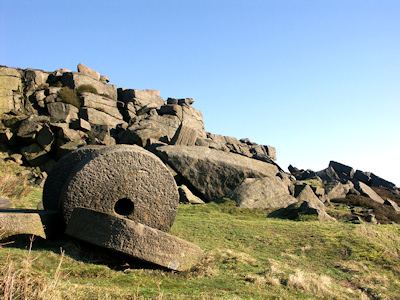
Hathersage is a popular centre for walkers and rock-climbers, for on its east side the village is overlooked by moorland and a line of gritstone edges of which Stanage Edge is the largest. There are also spectacular tors, such as Higgar Tor, and the enigmatic hillfort at Carl Wark, which has so far defied archaeologists' attempts to date it. Several of the edges were quarried and the area was a major source of millstones for grinding corn and metals.........Click for more

There will be three walks:

Sunday, 23 June 2013

A Walk from Hathersage

Walk Leader: Jenny Mathias
Distance: 12 Miles
Total ascent/descent: 2370ft


We will leave Hathersage along Baulk Lane, which was surrounded by fields full of buttercups and gardens arrayed with flowers.  We pass by North Lees Hall, the former home of the Eyre Family. A steady climb takes us onto Stannage Edge via Jacob's Ladder.  World famous in the climbing world and no doubt we will see many practicing their skills.  We head NW and drop down onto the Sheffield Country Walk to the Crow's Chin before returning to the edge and retracing our steps passing High Neb completing the Edge and dropping to the road and crossing Upper Burbage Bridge where we will pick up the Duke of Rutland Drive under Burbage Edge, this is also part of the Sheffield Country Walk.
Stannage Edge


On leaving this path we aim for Carl Wark, is it a fort or an ancient settlement?  If there is time we can climb up to the top before we make our way to Higger Tor.  We have to clamber over rocks to get to the top where we should get great views. Descending to the road we follow a steep downward path into Dale Bottom which eventually leads us back to Hathersage.

Carl Wark Fort
Owler Tor Millstone


This is a good walk which can be exposed so if the weather is inclement there are several escape routes.


B Walk from Hathersage

Walk Leader: Beverley Kelly
Distance: 8 Miles
Total Ascent/descent: 1400ft app 
Route Card and Elevation Profile click to enlarge


We shall explore a bit of gruesome history and discover some more recent history as we find where they quarried the stone for the Derwent Dams. We shall see some amazing stone formations as we survey the fantastic panorama of the Derbyshire Dales, but first we have a gentle flat stroll along the Derwent valley to Padley. 


Padley Hall has a gruesome history from Tudor times which I will tell you about as we view the remains. Adjacent is the steep slope of the old railway used to remove the stone for the Derwent dams and as we climb it we will discover historic remnants.


As we come out of the trees above the quarry we have ‘Surprise View’. Mother Cap is an extraordinary square stone shape, while Carl Wark is thought to have been an ancient Fort and Higger Tor gives us an easy bit of a climb.


Our descent is interesting and varied with clear views of the high levels we have been on. We shall pass interesting buildings and through wooded areas before we reach Hathersage and it's Gala in full swing.


This is a good B walk well suited for mid summer, with a steady climb and descent except for the 200ft of Bole Hill. We have plenty of time, but do carry enough fluid as the temperature is forecast to be high..


Photo's from the reccie here