Friday, 2 September 2011

A Walk from Bakewell

Walk Leader: Steve Edwards
Distance: 10 miles
Total Ascent: 1200 ft,  Descent: about 1700ft


This is a fairly easy A walk, more like a B+. The walk starts from the Wyedale car park which is just off the A6 between Buxton and Bakewell,so be prepared to leave the bus early. We walk through the valley of Deepdale rising rapidly as we head for the small village of Monyash once the centre of lead mining. From now on it is almost all descent heading for the beautiful Lathkill Dale, once a mining centre but now a tranquil valley with clear water and rare wild life. At the ancient village of Conksbury [now archeology as there are no dwellings left!] just after the spectacular series of weirs we head over the fields to Haddon House and the coach park at Bakewell.
A Walk Route


Moneyash Village Green
Batemans House. The minekeepers house built over a secret type of water pump to drain the mine
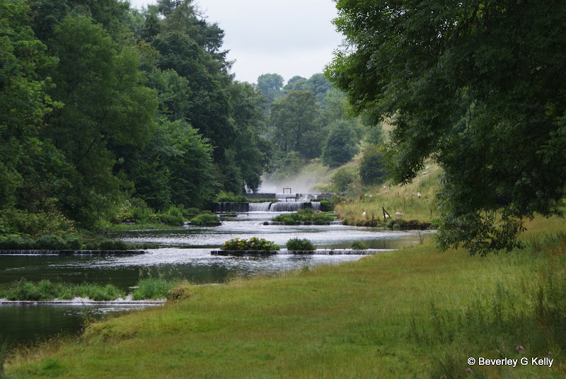
Between Conksbury and Over Haddon the Lathkill flows over a series of weirs, probably designed to hold back the waters for the mills, but it makes a lovely walk

B Walk at Bakewell

Walk Leader: George Mann
Distance: 8.5 Miles app
Total Ascent/Descent: 1025ft
approximate route, subject to alteration
Our walk today takes us initially alongside the River Wye before passing through a housing estate then up past the cemetery on our way towards Norton Barn Farm and the Village of Over Haddon. 

From there we cross over a series of fields heading for the village of Sheldon. We stop on the way to have a look around the  preserved buildings of the Magpie Mine one of the few reminders of the extensive lead and fluorspar mining that took place in the Peak District.
The Magpie Mine

Skirting the lower end of Sheldon we proceed downhill to Sheepwash Bridge in the village of Ashford in the Water and from there partially alongside the river our path leads us back to Bakewell. 
Looking towards Bakewell after Sheldon

There are about twenty stiles to negotiate the majority fairly easy  

C Walk at Bakewell

Walk Leader: Norman Jones
Distance: 6 miles app
Total Ascent/descent: 830ft
Height Gain about 500ft

The walk includes undulating parkland and woods, it's 6 miles long with a height gain of 500ft. Generally good underfoot.


We leave Bakewell in a south-easterly direction on a minor road and go under a bridge which is the southern end of the Monsal Trail. The road becomes a track, rising gently through undulating countryside and turning onto a woodland path. This rises steeply for about 400 yards, then becomes a flatter woodland route before reaching Carlton Pastures an ara of open parkland which soon slopes downwards. 


We continue on this parkland, which borders the Duke of Devonshire's Chatsworth Estate, for about a mile to join the Bakewell/Edensor minor road. This is our steep downhill route back into the centre of Bakewell for refreshments.

Saturday, 13 August 2011

August Walks from Ingleton on the Edge of the Yorkshire Dales

and will take place on

Saturday 13th August 2011
0800hrs prompt from short stay car park in the village

The limestone scenery of the Ingleton area
The village of Ingleton is surrounded by magnificent countryside with caves, waterfalls, and mountains. The Craven Fault crosses the area, and geological and archaeological sites abound.

Local attractions include:
  • The underground world of White Scar Cave, Britain's longest show cave
  • The Waterfalls Walk through woodland gorges with spectacular waterfalls (below)
  • Limestone peaks and scenery, with a direct route for the ascent of Ingleborough (above)
  • The nearby Settle-Carlisle railway and the famous Ribblehead viaduct
Ingleton has a wide range of accommodation, and is well placed for visiting the Yorkshire Dales, the Lake District, and the coast at Morecambe and Blackpool.
The A65 Leeds-Lakes road now by-passes Ingleton, which is only 16 miles from Hawes in Wensleydale and a similar distance to Lancaster.
Ingleton lies on one of the principal East-West routes across the Pennines used from prehistoric and Roman times. The remains of an Iron Age fort can be seen on the summit plateau of Ingleborough, at 723 metres (2372 feet), the best known of Yorkshire's Three Peaks. The ascent is by a relatively easy path from the village.


There will be three walks as normal.

 Walk Leaders

Wednesday, 3 August 2011

A Walk from Ingleton

Leader: Tony McDonald
Distance: 10.8 miles
Total Ascent/descent: 2600ft

'A' Party Route Map - click to enlarge
The walk starts in the town centre and commences a steady climb through the town towards Fell End. The route takes a scenic path between White Scars and Ingleborough Common. After around 3 miles, there is a quite challenging ascent to the summit of Ingleborough which is 724mtrs /2375ft above sea level. There is a wonderful view from the summit of Ingleborough. There is also a wonderful place to enjoy lunch on the descent side of Ingleborough.

After lunch the route takes a pleasant stroll along the mountain plateau, there is a short downward section which then turns almost due north and a challenging steep descent (note walking poles recommended if you use them, there is some scrambling on a few parts of the path). After the descent there is a new path across a bog which is now a nature reserve. Around halfway along this section there is a small village Chaple le Dale. There are pretty churches and interesting rocks and scenery. The westward section is through Scales Moor which has interesting limestone rock formations. 

At the end of this section there is an accent along good paths. At Scar end the route follows the famous Swilla Glen which is chargeable at £5-00 per person. Following the traditional route takes in the Breezly and snow falls. The total distance is 10.86 miles and the total accent/decent is 1118 metres.

'B' Walk at Ingleton

Walk Leader: John Smith
Total Distance: 8+ miles
Total ascent: 1400ft approx

Proposed walk, possibly subject to change.

Proposed A Walk Route - Click to enlarge.


I have recced two walks for today – not out of sheer enthusiasm I assure you !!

The first would take us up the river Twiss and, after a loop to add length, down the river Doe – this is the Waterfall walk which is tough with a multitude of steps up and down as you walk alongside each river. It would be amazing if there had been rain with the numerous waterfalls looking stunning, BUT there is a charge of £5 per person because the paths are on private land. I came back thinking that B group walkers would feel that £5 on top of the coach and coffee/beers afterwards was a bit steep.

So – I have charted the walk you now see but have to say that this will not have been recced before this note is posted on the website. I will be recceing it on Friday 5th August and have more detail for the clipboard on the coach.

The walk starts at 412 ft ascending over the next 3.4 miles to 1318ft followed by a further peak of 1044ft after 5.16 miles. The walk measures 8.12 miles and is over open land along lanes and paths. As you can see we will cross both rivers further upstream than Ingleton – both were dry on the first recce, though the waterfalls had plenty of water to sparkle.